Sequatchie River
| Sequatchie River | |
| River | |
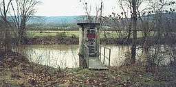
 A stream gage along the Sequatchie River near Whitwell, Tennessee | |
| Country | United States |
|---|---|
| State | Tennessee |
| Tributaries | |
| - right | Little Sequatchie River |
| Source | Brady Mountain in Cumberland County, Tennessee |
| - elevation | 2,460 ft (750 m) [1] |
| - coordinates | 35°49′17″N 84°58′40″W / 35.82139°N 84.97778°W [1] |
| Mouth | Tennessee River near Jasper, Tennessee |
| - elevation | 597 ft (182 m) [1] |
| - coordinates | 35°01′31″N 85°38′07″W / 35.02528°N 85.63528°WCoordinates: 35°01′31″N 85°38′07″W / 35.02528°N 85.63528°W [1] |
| Length | 116 mi (187 km) [2] |
| Basin | 602 sq mi (1,559 km2) [3] |
| Discharge | for Whitwell, Tennessee, 25.1 miles (40.4 km) above the mouth |
| - average | 745 cu ft/s (21 m3/s) (mean for water years 1920-1983)[4] |
| - max | 32,500 cu ft/s (920 m3/s) March 1973[4] |
| - min | 16 cu ft/s (0.5 m3/s) September 1925[4] |
 The Sequatchie drainage basin | |
The Sequatchie River is a 116-mile-long (187 km)[2] waterway that drains the Sequatchie Valley, a large valley in the Cumberland Plateau in Tennessee. It empties into the Tennessee River downstream from Chattanooga near the Tennessee-Alabama state line.
Hydrography
The Sequatchie River descends from a spring on the slopes of Brady Mountain, southeast of Crossville, to Devilstep Hollow, where it turns south and gradually drops from the Cumberland Plateau to the Sequatchie Valley. It receives the drainage of Grassy Cove, a pastoral limestone region several miles to the north from which the drainage has no surface outlet, through a spectacular series of underground karst passages.

The stream crosses into Bledsoe County near the head of the Sequatchie Valley. The Sequatchie Valley is traversed throughout much its length by U.S. Highway 127. The first sizeable town on the Sequatchie is Pikeville, the county seat of Bledsoe. State Route 30, which descends Walden's Ridge into the Valley and then climbs the escarpment back onto the plateau, crosses here.
Crossing into Sequatchie County, the stream flows into Dunlap. Just north of Dunlap, U.S. 127 turns southeastward, beginning the ascent onto Walden Ridge and eventually down into Chattanooga. A set of railroad tracks previously ran along the river from this point, testament to heavy underground coal extraction in years past. For almost the rest of its length the Sequatchie is paralleled by State Route 28. State Route 283 also runs along the base of the Walden's Ridge escarpment for several miles. The river then enters Marion County. The town of Whitwell is just a few miles into Marion County. Below Whitwell at the small community of Sequatchie (also known as Sequachee), the river receives the flow of the Little Sequatchie River, which descends from atop the Cumberland Plateau to the west. At Jasper, which is slightly west of the river, is a railroad junction. East of town is the crossing of U.S. Highway 41 by SR 28, and the bridge over the river. Shortly south of the Interstate 24 bridge is the mouth of the Sequatchie into the Guntersville Lake impoundment of the Tennessee River.
See also
References
- 1 2 3 4 U.S. Geological Survey Geographic Names Information System: Sequatchie River
- 1 2 "The National Map". U.S. Geological Survey. Retrieved Feb 16, 2011.
- ↑ U.S. Fish and Wildlife Services, "Imperiled Aquatic Species Conservation Strategy for the Upper Tennessee River Basin," 5 December 2014, p. 1.
- 1 2 3 United States Geological Survey, Water Resources Data Tennessee: Water Year 1983, Water Data Report TN-83-1, p. 154. Gaging station 03571000.
External links
| Wikimedia Commons has media related to Sequatchie River. |