Shelltown, San Diego

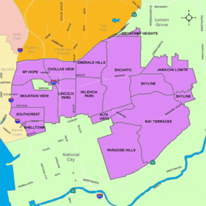
Shelltown is a neighborhood located within Southeast San Diego, approximately 5 minutes from downtown San Diego by car and 25 minutes by bicycle. It is bordered by National City on the south, Interstate 5 and Barrio Logan on the west, 43rd Avenue (a continuation of Highland Avenue) on the east, and Gamma Court and the neighborhood of Southcrest on the north.[1] Prior to the 1980s the northern border of Shelltown was National Ave and many residents still consider that the northern border.[2]
Due to the predominance of shells in the sandy soil, the neighborhood became known as "Shelltown." Located on a plateau just north and east of the 32nd Street Naval Station, Shelltown was a favorite location of housing for many of the early naval officers. Their ships were visible from their homes and were only moments away in the event they were called to duty[3] The majority of Shelltown consists of residential homes built between 1920 and 1969.[4] The Naval Base San Diego, an industrial park, and some commercial buildings are located just outside the western border of Shelltown along Main Street.
Mexican Americans have a long history in the area and began living in the area as early as the 1910s.
Shelltown/Southcrest contains a large mural, which is one of three by several artists that were done near three Southeast San Diego neighborhood entrances. Local activist and muralist Mario Torero was the lead artist for the Alpha Street piece.[5]
San Diego’s Southcrest Trails Park is located just north of the Shelltown neighborhood within the Chollas Creek floodplain, part of the smallest watershed in San Diego and containing the highest population density. The Park itself is located south of Boston Avenue and west of South 38th Street.[6] The park was scheduled to be completed in December 2012 [7]
Schools
Balboa Elementary School was recognized as one of six nationwide winners of the 2007 Intel Schools of Distinction awards, for excellence in math education in an elementary school program.[8][9][10]
Transportation
The area is served by the San Diego Trolley Blue Line at the Pacific Fleet station and the Route 929 bus via Main Street. The neighborhood also has quick access to Interstate 5, Interstate 15, and Interstate 805.
See also
References
- ↑ "Neighborhood profile from City-Data.com". Retrieved 2011-02-09.
- ↑ http://laprensa-sandiego.org/editorial-and-commentary/commentary/reunite-shelltown-in-district-9/
- ↑ http://www.sandiego.gov/planning/community/profiles/southeasternsd/pdf/sesdcpfv.pdf
- ↑ http://www.city-data.com/neighborhood/Shelltown-San-Diego-CA.html
- ↑ http://www.voiceofsandiego.org/survival/article_d4d1949a-c6a5-11df-a4d3-001cc4c002e0.html
- ↑ http://www.sandiego.gov/arts-culture/pdf/rfq.pdf
- ↑ http://www.sandiego.gov/planning/community/profiles/southeasternsd/chollascreek.shtml
- ↑ Tintocalis, Ana. "Balboa Elementary Wins $170,000 for Nation's Best Math Programs", KPBS-FM, May 30, 2007. Accessed June 17, 2007. "A San Diego school gets national attention for having a one of the country's top math programs. KPBS reporter Ana Tintocalis has more."
- ↑ "Balboa Named Nation’s Top Math Elementary: Intel’s award goes to Shelltown neighborhood school", San Diego City Schools press release dated June 1, 2007. Accessed June 17, 2007. " Balboa Elementary has been named top elementary school math program in Intel Corporation’s annual Schools of Distinction Award. "
- ↑ Fabiano, Giovanna. "Bergen Academies wins national math award", The Record (Bergen County), June 16, 2007. Accessed June 16, 2007.
Coordinates: 32°41′12″N 117°6′26″W / 32.68667°N 117.10722°W