Sidi Safi
| Sidi Safi | |
|---|---|
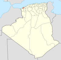
_location_map.svg.png) Location within Aïn Témouchent province | |
| Coordinates: 35°17′N 1°18′W / 35.283°N 1.300°WCoordinates: 35°17′N 1°18′W / 35.283°N 1.300°W | |
| Country | Algeria |
| Province | Aïn Témouchent |
| Area | |
| • Total | 65.52 km2 (25.30 sq mi) |
| Population (2010[1]) | |
| • Total | 7,782 |
| • Density | 120/km2 (310/sq mi) |
| Time zone | West Africa Time (UTC+1) |
Sidi Safi is a municipality in north-western Algeria.
References
This article is issued from Wikipedia - version of the 2/9/2016. The text is available under the Creative Commons Attribution/Share Alike but additional terms may apply for the media files.