Sierra de Francia Comarca
| Sierra de Francia Comarca Comarca de la Sierra de Francia | |
|---|---|
| Comarca | |
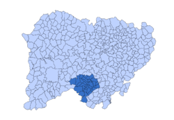
 Location of Sierra de Francia Comarca in Salamanca Province | |
| Country |
|
| Autonomous community | Castile and León |
| Province | Province of Salamanca |
| Municipalities |
List
|
| Area | |
| • Total | 630.84 km2 (243.57 sq mi) |
| Population | |
| • Total | 9,023 |
| • Density | 14/km2 (37/sq mi) |
| Demonym(s) | Serrano/Serrana |
| Time zone | CET (UTC+1) |
| • Summer (DST) | CEST (UTC+2) |
| Largest municipality | La Alberca |

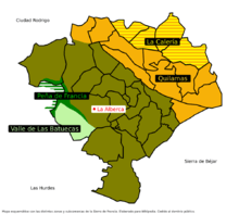
Map of the comarca
Sierra de Francia Comarca (Spanish: Comarca de los Montes de Toledo) is a comarca of Castile and León located at the southern end of the province of Salamanca, Spain. It borders with the Las Hurdes and Las Batuecas comarcas of Extremadura to the south; the Campo Charro to the north and the Sierra de Béjar to the east. The region is sparsely inhabited and its few towns have great cultural value.
It is named after the Sierra de Francia mountain system of the Sistema Central.[1] Some of the towns of the comarca have been officially declared Conjunto Histórico-Artístico owing to their cultural and architectural value.[2]
Municipal terms and villages
- La Alberca, capital of the comarca and declared Conjunto Histórico-Artístico
- Aldeanueva de la Sierra
- Aldehuela de Yeltes
- Barbalos
- La Bastida
- Berrocal de Salvatierra
- El Cabaco
- Casafranca
- Las Casas del Conde
- Casas de Monleón
- Cepeda
- Cereceda de la Sierra
- Cilleros de la Bastida
- Colmenar de Montemayor
- Cristóbal de la Sierra
- Endrinal
- Escurial de la Sierra
- Frades de la Sierra
- Fuenterroble de Salvatierra
- Garcibuey
- Guijuelo
- Herguijuela de la Sierra
- Herguijuela del Campo
- Horcajo de Montemayor
- Linares de Riofrío
- Madroñal
- El Maíllo
- Miranda del Castañar (Conjunto Histórico-Artístico)
- Mogarraz (Conjunto Histórico-Artístico)
- Molinillo
- Monforte de la Sierra
- Monleón (Conjunto Histórico-Artístico)
- Monsagro
- Morasverdes
- Nava de Francia
- Navarredonda de la Rinconada
- Pinedas
- Puebla de Yeltes
- La Rinconada de la Sierra
- San Esteban de la Sierra
- San Martín del Castañar (Conjunto Histórico-Artístico)
- San Miguel de Valero
- San Miguel del Robledo
- Santibáñez de la Sierra
- Los Santos
- Sequeros (Conjunto Histórico-Artístico)
- Serradilla del Arroyo
- La Sierpe
- Sotoserrano
- Tamames
- Tejeda y Segoyuela
- El Tornadizo
- Valdefuentes de Sangusín
- Valdelacasa
- Valdelageve
- Valdelosa
- Valero
- Valverde de Valdelacasa
- Villanueva del Conde
References
External links
- Ruta por el Parque Natural Las Batuecas-Sierra de Francia
- Patrimonio Natural de Castilla y León
- Centro de Interpretación de la Minería Romana del Oro. Las Cavenes
Coordinates: 40°15′N 6°00′W / 40.250°N 6.000°W
This article is issued from Wikipedia - version of the 5/22/2016. The text is available under the Creative Commons Attribution/Share Alike but additional terms may apply for the media files.