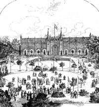
Skydebanehaven
.jpg)
Skydebanehaven (English. The Shooting Range Gardens) is a small public park in the heart of the Vesterbro district of Copenhagen, Denmark. Its name refers to the former shooting range of the Royal Copenhagen Shooting Society which used to be located on the site. The most distinctive feature of the park is the Neo-Gothic Shooting Range Wall which was constructed in 1887 to shield traffic on Istedgade from stray bullets. The other end of the park is bounded by the rear of the former headquarters of the Shooting Society, a Neoclassical mansion which now houses the Museum of Copenhagen.
History

In the 1750s Royal Copenhagen Shooting Society established a shooting range in the area which was located outside the fortified city, next to the main road leading in and out of the Western City Gate.[1] In 1782 the society acquired a 3.5 hectare piece of land, stretching from present day Vesterbrogade to the beach just south of the city. The society also built a mansion, completed in 1787, which was to serve as a venue for its active social life.[2]
When Vesterbro started to develop in the second half of the 19th century, after the city had been allowed to develop beyond its now decommissioned fortifications, the City expropriated much of the Shooting Society's grounds. In 1887 a tall wall was constructed to shield newly established Istedgade from stray bullets from the shooting range. The wall was designed by the architect Ludvig Knudsen in a Neo-Gothic style. Knudsen also modernized the interior of the Shooting Society's mansion in the 1890s and added a small new wing towards the gardens.
In 1949 the Society moved to Sølyst Manor at Klampenborg north of Copenhagen, while the City acquired the rest of the property on Vesterbrogade.[3]
Skydebanehaven today
The park contains a playground, lawns and flower beds.
See also
- Skydebanegade
References
- ↑ "Skydebrødrenes palæ". MIK. Retrieved 19 December 2009.
- ↑ "Museets historie". Københavns Bymuseum. Retrieved 19 December 2009.
- ↑ "Museets historie". Københavns Bymuseum. Retrieved 19 December 2009.
Coordinates: 55°40′16″N 12°33′14″E / 55.671°N 12.554°E