Tagapul-an, Samar
| Tagapul-an | |
|---|---|
| Municipality | |
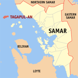 Map of Samar showing the location of Tagapul-an | |
.svg.png)  Tagapul-an Location within the Philippines | |
| Coordinates: 12°03′N 124°09′E / 12.050°N 124.150°ECoordinates: 12°03′N 124°09′E / 12.050°N 124.150°E | |
| Country |
 Philippines Philippines |
| Region | Eastern Visayas (Region VIII) |
| Province | Samar |
| District | 1st district of Samar |
| Barangays | 14 |
| Government[1] | |
| • Mayor | Vicente M. Limpiado Jr. (Nacionalista) |
| Area[2] | |
| • Total | 28.70 km2 (11.08 sq mi) |
| Population (2015)[3] | |
| • Total | 8,473 |
| • Density | 300/km2 (760/sq mi) |
| Time zone | PST (UTC+8) |
| ZIP code | 6712 |
| Dialing code | 55 |
| Income class | 5th class municipality |
Tagapul-an is a fifth class municipality in the province of Samar, Philippines. According to the 2015 census, it has a population of 8,473 people.[3] It is the farthest municipality from the province's mainland.
Barangays
Tagapul-an is politically subdivided into 14 barangays.[2]
- Baquiw
- Balocawe
- Guinbarucan
- Labangbaybay
- Luna
- Mataluto
- Nipa
- Pantalan
- Pulangbato
- San Vicente
- Sugod (Pob.)
- Suarez (Manlangit)
- San Jose (Pob.)
- Trinidad
Demographics
| Population census of Tagapul-an | ||
|---|---|---|
| Year | Pop. | ±% p.a. |
| 1990 | 6,760 | — |
| 1995 | 7,949 | +3.08% |
| 2000 | 8,370 | +1.11% |
| 2007 | 8,067 | −0.51% |
| 2010 | 7,828 | −1.09% |
| 2015 | 8,473 | +1.52% |
| Source: National Statistics Office[3][4] | ||
References
- ↑ "Municipalities". Quezon City, Philippines: Department of the Interior and Local Government. Retrieved 14 May 2013.
- 1 2 "Province: Samar (Western Samar)". PSGC Interactive. Makati City, Philippines: National Statistical Coordination Board. Retrieved 14 May 2013.
- 1 2 3 "Total Population by Province, City, Municipality and Barangay: as of May 1, 2010" (PDF). 2010 Census of Population and Housing. National Statistics Office. Retrieved 14 May 2013.
- ↑ "Province of Western Samar". Municipality Population Data. LWUA Research Division. Retrieved 21 August 2013.
External links
- Philippine Standard Geographic Code
- Philippine Census Information
- Local Governance Performance Management System
 |
San Vicente, Northern Samar Samar Sea |
| ||
| Cataingan, Masbate / Samar Sea |  |
Samar Sea / Calbayog | ||
| ||||
 | ||||
| Samar Sea Almagro |
Samar Sea Santo Niño |


 Province of Samar Province of Samar | |
|---|---|
Catbalogan (capital) | |
| Municipalities | |
| Component cities | |
This article is issued from Wikipedia - version of the 7/12/2016. The text is available under the Creative Commons Attribution/Share Alike but additional terms may apply for the media files.