Taillefer Rocks
|
Map of Taillefer Rocks and Schouten Island | |
  Taillefer Rocks Location of Taillefer Rocks in Tasmania | |
| Geography | |
|---|---|
| Location | East coast of Tasmania |
| Coordinates | 42°21′36″S 148°18′36″E / 42.36000°S 148.31000°ECoordinates: 42°21′36″S 148°18′36″E / 42.36000°S 148.31000°E |
| Archipelago | Schouten Island Group |
| Adjacent bodies of water | Tasman Sea |
| Total islands | 3 |
| Area | 15 ha (37 acres) |
| Administration | |
|
Australia | |
| State | Tasmania |
| Local government area | Glamorgan Spring Bay Council |
| Additional information | |
| Time zone | |
| • Summer (DST) | |
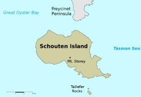
The Taillefer Rocks, part of the Schouten Island Group, are three small, rugged, granite islands, with a combined area of approximately 15 hectares (37 acres) lying close to the eastern coast of Tasmania, Australia, near the Freycinet Peninsula and lies within the Freycinet National Park.[1][2]
Flora and fauna
This is one of the few islands where Oyster Bay pines occur.
Recorded breeding seabird species are little penguin, short-tailed shearwater, fairy prion and common diving petrel. Reptiles present include the metallic skink, White's skink, spotted skink and mountain dragon. Australian fur seals haul-out there in small numbers.[2]
See also
References
- ↑ "Schouten" (Map). Tasmap. Tasmania: Mapping Division, Tasmanian Government. 1993. Retrieved 3 April 2015.
- 1 2 Brothers, Nigel; Pemberton, David; Pryor, Helen; Halley, Vanessa (2001). Tasmania’s Offshore Islands: seabirds and other natural features. Hobart: Tasmanian Museum and Art Gallery. ISBN 0-7246-4816-X.


East Coast region of Tasmania, Australia | |||||||
|---|---|---|---|---|---|---|---|
| Settlements | |||||||
| Governance former | |||||||
| Mountains | |||||||
| Protected areas, parks and reserves |
| ||||||
| Harbours, bays, inlets and estuaries | |||||||
| Landmarks |
| ||||||
| People of note | |||||||
| Islands |
| ||||||
| Books and newspapers | |||||||
| Flora, fauna, and fishlife | |||||||
| Bioregions | |||||||
| |||||||
This article is issued from Wikipedia - version of the 8/15/2015. The text is available under the Creative Commons Attribution/Share Alike but additional terms may apply for the media files.