Tannbach (Saale)
| Tannbach | |
|---|---|
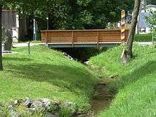 The Tannbach in Mödlareuth | |
| Country | Germany |
| Basin | |
| Main source |
east of Gefell-Gebertsreuth 620 m (2,030 ft) NN 50°26′11.44″N 11°54′12.54″E / 50.4365111°N 11.9034833°E |
| River mouth |
Saale (between Joditz and Hirschberg ) 445 m (1,460 ft) NN 50°23′38″N 11°50′06″E / 50.3939°N 11.8349°ECoordinates: 50°23′38″N 11°50′06″E / 50.3939°N 11.8349°E |
| Progression | Saale > Elbe > North Sea |
| Physical characteristics | |
| Length | 8.7 km (5.4 mi) |
| Features | |
| Tributaries |
|
Tannbach is a brook that is around six kilometers long in north-east Bavaria and southern Thuringia, Germany.
The source is located east of Gefell in the Saale-Orla-Kreis district, in Thuringia, Germany. Initially it flows south through Gebersreuth before reaching Mödlareuth. During the Cold War the little brook marked the border between West- and East Germany and divided the little village into two parts. After Mödlareuth it flows in south-westerly direction before it joins the also known as the Saale as right tributary.
See also
This article is issued from Wikipedia - version of the 6/16/2016. The text is available under the Creative Commons Attribution/Share Alike but additional terms may apply for the media files.