Tarn Taran district
| Tarn Taran district ਤਰਨ ਤਾਰਨ ਜ਼ਿਲ੍ਹਾ | |
|---|---|
| District | |
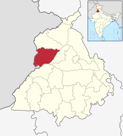
 Location in Punjab, India | |
| Coordinates: 31°27′36″N 74°55′48″E / 31.46000°N 74.93000°ECoordinates: 31°27′36″N 74°55′48″E / 31.46000°N 74.93000°E | |
| Country |
|
| State | Punjab |
| Region | Majha |
| Named for | The boat that takes one across (the ocean of existence) |
| Headquarters | Tarn Taran Sahib |
| Government | |
| • Administrator of District | Harmesh Singh Pabla |
| Area | |
| • Total | 2,414 km2 (932 sq mi) |
| Population (2011)‡[›] | |
| • Total | 1,120,070 |
| • Density | 460/km2 (1,200/sq mi) |
| Languages | |
| • Official | Punjabi |
| Time zone | IST (UTC+5:30) |
| Literacy | 69.4% |
| Website |
tarntaran |

Tarn Taran district (Punjabi:ਤਰਨ ਤਾਰਨ ਜ਼ਿਲਾ) is one of the districts in the Majha region of Punjab in North-West Republic of India. The main cities are Tarn Taran Sahib and Patti. The City of Taran Taran is a holy place for Sikhs.
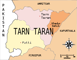
Tarn Taran district was formed in 2006 from Amritsar District. The declaration to this effect was made by Captain Amarinder Singh, Ex-Chief Minister of Punjab, during the celebrations marking the martyrdom day of Sri Guru Arjan Dev Ji. With this, it became the 19th district of Punjab. It has three tehsils, which are Patti, Khadur Sahib and Tarn Taran. The District Headquarters is headed by the Deputy Commissioner, along with a Senior Superintendent of Police, the Additional District and Sessions Judge, the Chief Judicial Magistrate, Civil Surgeon, district Education Officer, Improvement Trust and a Municipal Council.
Towns and villages
The villages and towns of Tarn Taran District include:
- Patti
- Munda Pind
- Dhotian
- Jamarai
- bhail
- Johal
- Johal Dhai Wala
- Lohar
- Gharka
- Sangatpur
- Rani Walah
- Brahmpur
- Chohla Sahib
- Kulla
- Khadur Sahib
- Rataul
- Kotli
- Behla
- Daburji
- Bath
- Dasoowal
- Jalalabad
- Jandiala
- Kad gill kalan
- Chabal Kalan
- Naushehra Pannuan
- Mohanpur
- Sheron
- Sarhali
- Sarhali Khurd
- Bhikhiwind
- Khalra
- Jandoke
- Dhollan
- Thatthi
- Rajoke
- Lakhna
- kalia sataktra
- Vaan
- Khem Karan
- Goindwal Sahib
- Panjwar
- Chohla Sahib
- Teja singhwala
- Chhina
- Sur Singhwala
- Cheema Kalan
- Sarli Kalan
- Sarli Khurd
- Thathi Khara
- Narli
- Narla
- Valtoha
- Khalra
- Gaggobua
- Naurangabad
- Palasour
- Padhari Kalan
- Padhari Khurd
- Jaura
- Bahmniwala
- uboke
- Mughalwala
- Manihala Jai Singh
- Pahuwind
- Chela
- Gharyala
- Cheema Khurd
- Sarai Amanat Khan
- Gandiwind
- Bagrian
- Tur Sahib
- Rattoke
- Varpal
- Bala Chak
- Gohalwar Varpal
- Fatehabad
- Saido
- Amishah
- Mari Megha
- Sohal
- Lalu Ghumman
- Kila Kavi Santokh Singh
(formerly Sarai Nurdin) - Dall
- Aliwal
- Gazal
- Vairowal
- Thathi Jaimal Singh
- Assal Uttar
- Mugal Chack Pannuan
- Vain Poin (Apneet Singh wala)
- Mughal chak Gill
- Kad Gill
- Kakka Kandiala
- Mari kamboki
Demographics
According to the 2011 census Tarn Taran district has a population of 1,120,070 out of which more than 93% people are Sikhs.[1] The population of the district is roughly equal to the nation of Cyprus[2] or the US state of Rhode Island.[3] This gives it a ranking of 413th in India (out of a total of 640).[1] The district has a population density of 464 inhabitants per square kilometre (1,200/sq mi) .[1] Its population growth rate over the decade 2001-2011 was 19.28%.[1] Tarn Taran has a sex ratio of 898 females for every 1000 males,[1] and a literacy rate of 69.4%.[1]
Notable Persons
Nizam Lohar,19th century heroic rebel of punjab
See also
- Tarn Taran (Lok Sabha constituency)
- MLA Adeshpartap singh kairon (SAD)
References
- 1 2 3 4 5 6 "District Census 2011". Census2011.co.in. 2011. Retrieved 2011-09-30.
- ↑ US Directorate of Intelligence. "Country Comparison:Population". Retrieved 2011-10-01.
Cyprus 1,120,489, July 2011 est.
- ↑ "2010 Resident Population Data". U. S. Census Bureau. Retrieved 2011-09-30.
Rhode Island 1,052,567
- ↑ http://www.census2011.co.in/data/religion/district/603-tarn-taran.html
 |
Amritsar district |  | ||
| Pakistan | |
Kapurthala district | ||
| ||||
| | ||||
| Firozpur district |
