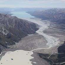
Tasman River
| Tasman River | |
|---|---|
 Tasman River between Tasman Lake in the foreground, and Lake Pukaki in the distance | |
| Country | New Zealand |
| Basin | |
| Main source |
Tasman Glacier, Murchison Glacier 715 m (2,346 ft)[1] 43°42′23″S 170°10′18″E / 43.7064°S 170.1717°E |
| River mouth |
Lake Pukaki 518 to 532 m (1,699 to 1,745 ft)[2] 43°54′18″S 170°10′30″E / 43.905°S 170.175°ECoordinates: 43°54′18″S 170°10′30″E / 43.905°S 170.175°E |
| Physical characteristics | |
| Length | 25 km (16 mi)[3] |
The Tasman River is an alpine braided river flowing through Canterbury, in New Zealand's South Island.
The river's headwaters are in Aoraki/Mount Cook National Park, where it is the outflow of the proglacial Tasman Lake. It is also fed by the glacial waters of the tributary Murchison River, from Murchison Glacier, and the short Hooker River, an outflow of the proglacial lakes of the Hooker and Mueller glaciers.
The Tasman River flows south for 25 kilometres (16 mi) through the wide flat-bottomed Tasman Valley in the Southern Alps and into the northern end of the glacial lake Pukaki, this forming part of the ultimate headwaters of the Waitaki hydroelectric scheme.
See also
References
- ↑ "Tasman Lake, Canterbury - NZ Topo Map". NZ Topo Map. Land Information New Zealand. Retrieved 2016-09-16.
- ↑ "Lake Pūkaki lake levels". Meridian Energy. Retrieved 2016-09-16.
- ↑ "Tasman River, Canterbury - NZ Topo Map". NZ Topo Map. Land Information New Zealand. Retrieved 2016-09-16.
External links
| Wikimedia Commons has media related to Tasman River. |
This article is issued from Wikipedia - version of the 9/15/2016. The text is available under the Creative Commons Attribution/Share Alike but additional terms may apply for the media files.