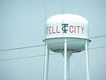
Tell City, Indiana
| City of Tell City | |
|---|---|
| City | |
|
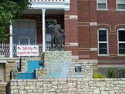
A statue of William Tell and his son sits upon a fountain outside city hall. It is a famous city landmark. | |
 Location in the state of Indiana | |
| Coordinates: 37°57′11″N 86°45′41″W / 37.95306°N 86.76139°WCoordinates: 37°57′11″N 86°45′41″W / 37.95306°N 86.76139°W | |
| Country | United States |
| State | Indiana |
| County | Perry |
| Township | Troy |
| Acquired | July 1857 |
| Founded | August 1858 |
| Government | |
| • Mayor | Jim Adams (R) |
| Area[1] | |
| • Total | 4.64 sq mi (12.02 km2) |
| • Land | 4.53 sq mi (11.73 km2) |
| • Water | 0.11 sq mi (0.28 km2) 2.37% |
| Elevation | 420 ft (128 m) |
| Population (2010)[2] | |
| • Total | 7,272 |
| • Estimate (2012[3]) | 7,238 |
| • Density | 1,605.3/sq mi (619.8/km2) |
| Time zone | CST (UTC-6) |
| • Summer (DST) | CDT (UTC-5) |
| ZIP code | 47586 |
| Area code(s) | 812 |
| FIPS code | 18-75248[4] |
| GNIS feature ID | 0451548[5] |
| Website | http://tellcityindiana.com/ |
Tell City is a city in Troy Township, Perry County, Indiana, United States, along the Ohio River. The population was 7,272 at the 2010 census. The city is the county seat of Perry County.[6]
History
Tell City traces its 150+ year old roots to a meeting in Cincinnati, Ohio, in November 1856. A group of Swiss-German immigrants met there to organize a society known as the "Swiss Colonization Society." Its purpose was to obtain affordable homesteads for mechanics, shopkeepers, factory workers and small farmers in a location where all could live in harmony.
The Society decided to purchase a tract of land three miles (5 km) square to be surveyed into a city plot. The group sent out to purchase the land was told to keep in mind a healthful climate, fertile soil, good water, ample timber, and a location near a navigable river and a railroad, if possible. Purchase of such a site was made in July 1857. The tract, containing 4,152 acres (16.80 km2), was laid out in 392 town blocks with 7,328 building lots and 294 garden lots.

Before the settlers arrived, a name for the new town was selected. Initially called Helvetia, it was soon renamed Tell City, a name easier to pronounce and remember for English-speaking people. It was named for the legendary Swiss hero and liberator, William Tell.[7]
Indicative of the foresightedness of Tell City's founders are the wide streets. They are named for great persons of the military, arts, letters and science: DeKalb, Watt, Winkelreid, Steuben, Payne, Herrman, Reubens, Lafayette, Schiller, Tell, Fulton, Jefferson, Mozart, Franklin, Humboldt, Pestalozzi, Washington, Blum and Gutenberg.
With 100 years of recorded history, the citizens of Tell City held a centennial celebration August 10–17, 1958 in honor of the early settlers and the founding of Tell City. After the success of the Centennial, the Tell City Historical Society decided to sponsor a festival in 1959 to determine if the community would support it as an annual event. The festival, named Schweizer Fest (Swiss Fest), was a great success. Today, the festival remains one of Indiana's longest-running community festivals.
On March 17, 1960, Northwest Orient Airlines Flight 710, a Lockheed Electra turboprop airliner flying from Chicago to Miami lost a wing due to aerodynamic flutter and crashed in southern Indiana near Tell City. All 63 on board, including the crew, perished. The victims were impacted in a 30-foot-deep (9.1 m) crater, which became their final resting place. A monument with the names of the victims and the date of the tragedy marks the grave.
Steamboat 'Tell City'
The steamboat 'TELL CITY' was built in 1889 and named after Tell City. It was used to carry passengers and freight on the Ohio River until it sank in April 6, 1917 in Little Hocking, Ohio. The pilothouse survived the sinking and is the oldest remaining steamboat pilothouse, located at the Ohio River Museum in Marietta, Ohio.[8]
Schools
Tell City is home to the Tell City High School Marksmen. The school is in Class 2A for football, basketball, and baseball. The boys basketball team was a traditional power, winning 34 sectionals, five regionals and one semi-state, the latter coming in 1961 when the Marksmen won the southern semi-state, thus reaching the state championship round. The Marksmen were led by Indiana Basketball Hall of Fame guard, future University of Kentucky star Tommy Kron. The coach that season was Orlando 'Gunner' Wyman, an Indiana Hall of Fame head coach who won the State Championship at Vincennes Lincoln High in 1981.
The Marksmen also boast of three other Indiana Hall of Fame head coaches, Ray Eddy, Andy Taff and Bob Lochmueller. Eddy went on to coach the Madison, Indiana Cubs to a state final appearance in 1949 and the state championship in 1950. He then returned to his alma mater, Purdue University where he was the head coach for fifteen seasons. One other basketball player left out was Burke Scott who played as a starter on the 1953 I.U. NCAA champions.
Taff, a former star for Eddy at Madison, began his high school coaching career in the 1950-51 season at Tell City; winning an IHSAA Sectional behind the play of Burke Scott, a future Indiana University starting guard on the 1953 Indiana University NCAA Championship squad. Scott, a 1951 graduate of Tell City High School, was inducted into the Indiana Basketball Hall of Fame in 2011.
Steve Lochmueller, Bob's son, is also an Indiana Basketball Hall of Fame center and former University of Kentucky star. The Marksmen football team has won nine sectionals, four regionals and one semi-state, with the latter being in 1986 when they lost the state championship final.
The Marching Marksmen band currently competes in ISSMA Class D and are 20-time state finalists.
Geography
Tell City is located at 37°57′11″N 86°45′41″W / 37.953036°N 86.761372°W.[9]
According to the 2010 census, Tell City has a total area of 4.635 square miles (12.00 km2), of which 4.53 square miles (11.73 km2) (or 97.73%) is land and 0.105 square miles (0.27 km2) (or 2.27%) is water.[1]
Demographics
| Historical population | |||
|---|---|---|---|
| Census | Pop. | %± | |
| 1860 | 1,030 | — | |
| 1870 | 1,660 | 61.2% | |
| 1880 | 2,112 | 27.2% | |
| 1890 | 2,094 | −0.9% | |
| 1900 | 2,680 | 28.0% | |
| 1910 | 3,369 | 25.7% | |
| 1920 | 4,086 | 21.3% | |
| 1930 | 4,873 | 19.3% | |
| 1940 | 5,395 | 10.7% | |
| 1950 | 5,735 | 6.3% | |
| 1960 | 6,609 | 15.2% | |
| 1970 | 7,933 | 20.0% | |
| 1980 | 8,704 | 9.7% | |
| 1990 | 8,088 | −7.1% | |
| 2000 | 7,845 | −3.0% | |
| 2010 | 7,272 | −7.3% | |
| Est. 2015 | 7,255 | [10] | −0.2% |
2010 census
As of the census[2] of 2010, there were 7,272 people, 3,224 households, and 1,971 families residing in the city. The population density was 1,605.3 inhabitants per square mile (619.8/km2). There were 3,574 housing units at an average density of 789.0 per square mile (304.6/km2). The racial makeup of the city was 97.5% White, 0.3% African American, 0.3% Native American, 0.7% Asian, 0.3% from other races, and 0.9% from two or more races. Hispanic or Latino of any race were 1.0% of the population.
There were 3,224 households of which 28.4% had children under the age of 18 living with them, 44.9% were married couples living together, 11.4% had a female householder with no husband present, 4.8% had a male householder with no wife present, and 38.9% were non-families. 34.3% of all households were made up of individuals and 16.5% had someone living alone who was 65 years of age or older. The average household size was 2.23 and the average family size was 2.84.
The median age in the city was 42 years. 22% of residents were under the age of 18; 7.6% were between the ages of 18 and 24; 24.1% were from 25 to 44; 27% were from 45 to 64; and 19.3% were 65 years of age or older. The gender makeup of the city was 47.5% male and 52.5% female.
2000 census
As of the census[4] of 2000, there were 7,845 people, 3,404 households, and 2,161 families residing in the city. The population density was 1,721.4 people per square mile (664.2/km²). There were 3,700 housing units at an average density of 811.9 per square mile (313.3/km²). The racial makeup of the city was 98.65% White, 0.27% African American, 0.18% Native American, 0.23% Asian, 0.04% Pacific Islander, 0.14% from other races, and 0.50% from two or more races. Hispanic or Latino of any race were 0.89% of the population.
There were 3,404 households out of which 26.4% had children under the age of 18 living with them, 49.3% were married couples living together, 10.7% had a female householder with no husband present, and 36.5% were non-families. 33.3% of all households were made up of individuals and 17.2% had someone living alone who was 65 years of age or older. The average household size was 2.25 and the average family size was 2.85.
In the city the population was spread out with 21.9% under the age of 18, 9.2% from 18 to 24, 25.4% from 25 to 44, 22.7% from 45 to 64, and 20.8% who were 65 years of age or older. The median age was 41 years. For every 100 females there were 89.5 males. For every 100 females age 18 and over, there were 84.6 males.
The median income for a household in the city was $31,045, and the median income for a family was $41,300. Males had a median income of $31,908 versus $21,232 for females. The per capita income for the city was $17,443. About 8.0% of families and 11.2% of the population were below the poverty line, including 15.7% of those under age 18 and 8.8% of those age 65 or over.
Notable people
There have been several notable residents and former residents of Tell City, Indiana.
- Ray Eddy - former college basketball coach
- Bob Polk - former college basketball coach
- Krista Blunk - former college basketball star
- Tom Kron - former college (Univ of Kentucky) and professional basketball star
See also
References
- 1 2 "G001 - Geographic Identifiers - 2010 Census Summary File 1". United States Census Bureau. Retrieved 2015-07-29.
- 1 2 "American FactFinder". United States Census Bureau. Retrieved 2012-12-11.
- ↑ "Population Estimates". United States Census Bureau. Retrieved 2013-06-25.
- 1 2 "American FactFinder". United States Census Bureau. Retrieved 2008-01-31.
- ↑ "US Board on Geographic Names". United States Geological Survey. 2007-10-25. Retrieved 2008-01-31.
- ↑ "Find a County". National Association of Counties. Retrieved 2011-06-07.
- ↑ Thrasher, M. A.: A History of Tell City, Tell City Historical Society, 1989. Retrieved 2008-12-04.
- ↑ http://www.amystrahlerphotography.com/p264905899/h2BCAD48#h2bcad48
- ↑ "US Gazetteer files: 2010, 2000, and 1990". United States Census Bureau. 2011-02-12. Retrieved 2011-04-23.
- ↑ "Annual Estimates of the Resident Population for Incorporated Places: April 1, 2010 to July 1, 2015". Retrieved July 2, 2016.
- ↑ "Census of Population and Housing". Census.gov. Retrieved June 4, 2015.
External links
- City website
- Perry County News, local newspaper
- Perry County Chamber of Commerce, local Chamber of Commerce
