Tennessee State Route 99
| ||||
|---|---|---|---|---|
 | ||||
| Route information | ||||
| Maintained by TDOT | ||||
| Length: | 126.7 mi (203.9 km) | |||
| Major junctions | ||||
| South end: |
| |||
| East end: |
| |||
| Location | ||||
| Counties: | Wayne, Lewis, Maury, Marshall, Rutherford, Cannon | |||
| Highway system | ||||
| ||||


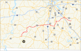
State Route 99 is a long east–west highway in Middle Tennessee. The route travels through large sections of rural areas and for most of the length is a secondary highway. The route begins near Waynesboro and ends in Bradyville after logging 128.4 mi (206.6 km) and passing through six counties.
The highway begins at an intersection with U.S. Route 64 as a secondary route that was the former route of US 64 in Wayne County. From there it travels through Lewis County where it meets U.S. Route 412. At this point SR-99 is concurrent with US 412 though it is not signed. This remains until US 412 and SR-99 enters Maury County. East of Columbia, SR-99 separates from US 412 at Interstate 65 as US 412 ends. From here SR-99 crosses into Marshall County before entering Rutherford County. In Murfreesboro, SR-99 is unsigned from the intersection with SR-96 to US 70S and US 41. Then SR-99 heads into Cannon County to its terminus.
Route description
| county | mi[1] | km | |
| Wayne | 14.1 | 22.7 | |
| Lewis | 30 | 48.3 | |
| Maury | 31.6 | 50.9 | |
| Marshall | 14.7 | 23.7 | |
| Rutherford | 36.6 | 58.9 | |
| Cannon | 1.4 | 2.3 | |
| Total | 128.4 | 206.6 | |
Major intersections
| County | Location | mi[2] | km | Destinations | Notes |
|---|---|---|---|---|---|
| Wayne | Waynesboro | 0.0 | 0.0 | ||
| Lewis | Hohenwald | 28.5 | 45.9 | SR 20 concurrency begins | |
| 28.8 | 46.3 | SR 48 concurrency begins | |||
| 29.2 | 47.0 | SR 48 and SR 20 concurrencies end; US 412 concurrency begins as SR 99 becomes unsigned | |||
| 37.4 | 60.2 | ||||
| Maury | | 47.0 | 75.6 | ||
| Columbia | 57.2 | 92.1 | US 412 Bus. concurrency begins | ||
| 59.3 | 95.4 | SR 50 concurrency begins | |||
| 60.4 | 97.2 | SR 50 concurrency ends | |||
| 61.4 | 98.8 | ||||
| 62.0 | 99.8 | US 31 and SR 7 concurrencies begin | |||
| 62.5 | 100.6 | SR 7 concurrency ends | |||
| 63.9 | 102.8 | US 412 Bus. and US 31 concurrencies end; US 412 concurrency begins | |||
| 71.0 | 114.3 | I-65 exit 46 | |||
| SR 99 signage resumes | |||||
| | 74.9 | 120.5 | US 431 and SR 106 concurrencies begin | ||
| | 75.7 | 121.8 | US 431 and SR 106 concurrencies end | ||
| Marshall | | 79.5 | 127.9 | ||
| Chapel Hill | 83.1 | 133.7 | US 31A and SR 11 concurrencies begin | ||
| SR 99 reverts to a secondary route | |||||
| 83.9 | 135.0 | ||||
| 86.4 | 139.0 | US 31A and SR 11 concurrencies end | |||
| Rutherford | Eagleville | 92.9 | 149.5 | US 41A and SR 16 concurrencies begin | |
| 94.4 | 151.9 | US 41A and SR 16 concurrencies ends; SR 269 concurrency begins | |||
| | 99.9 | 160.8 | SR 269 concurrency ends | ||
| Murfreesboro | 110.3 | 177.5 | I-24 exit 80 | ||
| 111.6 | 179.6 | SR 96 concurrency begins; SR 99 unsigned | |||
| 112.2 | 180.6 | US 70S and SR 1, US 41, US 231 and SR 10 concurrencies being; SR 96 concurrency ends | |||
| 112.9 | 181.7 | US 231 and SR 10 concurrencies end | |||
| 113.4 | 182.5 | US 70S and SR 1 concurrencies ends; SR 2 concurrency begins | |||
| 113.5 | 182.7 | US 41 and SR 2 concurrencies end | |||
| Cannon | Bradyville | 128.4 | 206.6 | ||
1.000 mi = 1.609 km; 1.000 km = 0.621 mi
| |||||
References
- ↑ County Maps-TDOT
- ↑ retrieved from DeLorme Street Atlas USA
External links
-
 Media related to Tennessee State Route 99 at Wikimedia Commons