Termancia (Tiermes)
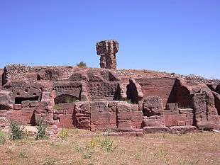
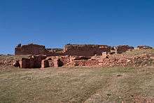
Tiermes was a Celtiberian hill fort (name: Termes) and later a Roman Municipium. It is remarkable for its impressive site on an arid red sandstone hill and for the way buildings have been carved in the solid rock.
The city was an ally of Numancia during the Celtiberian Wars. It is located on the edge of the Douro Valley in Spain, and close to the town of Montejo de Tiermes (Soria, Castile and León).
Roman History

The wealth of Tiermes in Celtiberian and Roman times came possibly from sheep farming (there are indications of an annual transfer of flocks between the northern plateau and Extremadura) and from deposits of iron ore and other metals in their area of influence.
The conquest of the Iberian Peninsula by Rome was a long process that lasted two centuries. One of the highlights was the Celtiberian Wars that led to the incorporation of much of Celtiberia up to the middle of the Alto Douro after the fall of Numantia in 133 BC. During this phase Termes was attacked by the Roman consul Q. Pompey in 141 BC, who signed a treaty with Termes in 139 BC, along with Numantia. The treaty was overruled by the Roman Senate, though continued hostilities did not directly affect Termes. Finally, at the end of the 2nd century BC, Rome restarted the conquest beyond Numantia; Termes fell in 98 BC, after the assault of the consul Titus Didius, who forced the inhabitants to move down to the plain, which according to archaeological data lasted only one or two decades. Afterwards Termes paid tribute (stipendiaria civitas), beginning a slow process of Romanisation.
From 70 BC the city began major urban renewal, using the three terraces of the hill, especially the middle, where the most important buildings would be located in the future.
The city was probably given the title Municipium during the reign of Emperor Tiberius. Termes was assigned to the Conventus Cluniensis and thereafter the Hispanic-Roman city began to take shape, whose period of greatest splendour was between the first and second centuries AD. It was endowed with large public buildings, two fora (first Julio-Claudian and later a Flavian forum), thermal baths, a possible theatre, an aqueduct and urban development suited to the location of the city on a sandstone bluff surrounded by river gorges and forests.

A particular characteristic of Tiermes, and most spectacular today, is the technique of carving buildings into the solid rock, later perfected with the introduction of Roman construction techniques. The city has numerous remains of buildings with this type of architecture, both private buildings (House of the Niches, Aqueduct House ...) and public (rock bleachers, Theatre, ...) and infrastructure (urban channels aqueduct, drainage, pathways, ...).

The construction of the wall in the late third century AD indicates that the city maintained its character which lasted at least until the middle of IVth c. AD. Tiermes faded during late antiquity and very little of what happened in the city during the Visigoth and Islamic periods is known.
Archaeology
See http://www.museodetiermes.es/English/Tiermes-2014/
The archaeological remains are located on several terraces and in the southern plain:
Flight of steps carved into the rock: monumental public space of uncertain date and function, with steps divided into sectors and access stairways, near the door of the Sun, one of the ancient entrances. Southern rock complex: the remains of homes probably originating Celtiberian era, carved into the rocks on two floors, in the back, and with masonry facade of the Roman era. There are 11 houses divided into two zones, separated by a staircase. The "house of the Niches", among them, also shows an upper floor. Canal aqueduct: carved into the rock, it brought water from the hill to the Roman city, partly underground West Gate: pedestrian access to the city "House of the aqueduct", residence of 1800 sqm with 35 rooms on different levels connected by stairs. The foundation was cut into the hill, while the walls were plastered and decorated with murals. Forum with a temple dedicated to the imperial cult, arcaded square and a macellum with taverns.
References
1 / ESSENTIAL REFERENCES Greek and Latin
Appian, Iber. 76-77-79.
Diodorus of Sicily, XXXIII, 16-17.
Floro, III, 10.9.
Livio, Epit. LIV.
Polybius, Lib. XXXV.
Pliny, Nat. Hist., III, 27.
Ptolemy II, 6.55.
Sallust, Hist ,. II, 95.
Tacitus, Ann., IV, 45, 1-2.
The Ravenate, p. 311.6.
2 / MAIN BIBLIOGRAPHY OF EXCAVATION AND GUIDES
www.tiermes.net
www.bne.es.
MARTINEZ CABALLERO, S. and ALDECOA RUIZ, A .: "brief to visit Tiermes Guide." Tiermes LIFE Project (2009). freely available in PDF format on the web www.tiermes.net.
ARGENTE OLIVER, JL and DIAZ DIAZ, A: "The Celtiberian necropolis of Tiermes (Carratiermes, Soria)" Archaeological Newscast Hispanic, 7, 1979): pp. 95-151.
ARGENTE OLIVER, JL et al: "Tiermes I (Campaigns 1975-1978) Works of excavations carried out in the Roman city and in the vicinity of the Romanesque Chapel of Our Lady of Tiermes.". Archaeological excavations in Spain, 111, Madrid, 1980.
ARGENTE OLIVER, JL et al: "Tiermes II (Campaigns 1979-1980) Excavations in the Roman City and the Medieval Necropolis.". Archaeological excavations in Spain, 128. Madrid, 1984.
HOUSE MARTÍNEZ, C. de la and others: "Tiermes III Excavations in the Roman City and the Medieval Necropolis (Campaigns 1981-1984).". Archaeological excavations in Spain, 166. Madrid, 1994.
ARGENTE OLIVER, JL and Diaz Diaz, A .: "Tiermes IV. The Aqueduct House (Domus high imperial city of Tiermes) (Campaigns 1979-1986)". Archaeological excavations in Spain, 167. Madrid, 1994.
ARGENTE OLIVER, JL and Diaz Diaz, A .: "Tiermes V. Celtibérica of Carratiermes Necropolis" (Campaigns 1979 and 1986-1991) ". Edition directed by JLArgente and basically completed in 1997-1998, reviewed by the archaeological team of JL Argente (Alberto Bescós, Santiago Martínez Caballero, Arturo Aldecoa Ruiz and others) in 1999-2000 and published by the JCyL in 2001.
ORTEGO AND COLD, T .: Tiermes archaeological guide. Madrid, 1980.
ARGENTE OLIVER, JL and Diaz Diaz, A .: Tiermes guide archaeological site and museum. Soria, 1995. Junta de Castilla y León
Coordinates: 41°19′51″N 3°08′56″W / 41.3308°N 3.1488°W