Texas State Highway 30
"TX 30" redirects here. TX 30 may also refer to Texas's 30th congressional district.
| ||||
|---|---|---|---|---|
 | ||||
| Route information | ||||
| Maintained by TxDOT | ||||
| Length: | 53.2 mi[1] (85.6 km) | |||
| Existed: | 1960 – present | |||
| Major junctions | ||||
| West end: |
| |||
|
| ||||
| East end: |
| |||
| Location | ||||
| Counties: | Brazos, Grimes, Walker | |||
| Highway system | ||||
| ||||

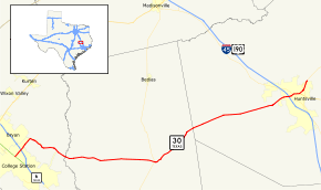
State Highway 30, or SH 30, runs from Business SH 6-R in College Station via Roans Prairie to SH 19 in Huntsville. This route was designated in 1960, replacing SH 45. It is known as Harvey Road between Business SH 6-R and FM 158 in College Station, as 11th Street between I-45 and US 190 (Phelps Dr) in Huntsville, and as Riverside Drive east of US 190 (Phelps Dr) in Huntsville.
Previous routes

SH 30 was a route proposed in 1919 to run from Wichita Falls to Sabinal. The route remains mostly the same, with only the southern portion rerouted into Del Rio by 1931. By 1938, the highway was cancelled as U.S. Highway 277 was routed over its entirety from Del Rio to Wichita Falls.
Counties and junctions
| County | Location | mi | km | Destinations | Notes |
|---|---|---|---|---|---|
| Brazos | College Station | ||||
| Interchange; future I-14 | |||||
| Grimes | Carlos | ||||
| Roans Prairie | |||||
| Shiro | |||||
| | |||||
| Walker | | ||||
| | |||||
| | |||||
| Huntsville | Interchange | ||||
| West end of US 190 overlap | |||||
| West end of SH 75 overlap | |||||
| East end of SH 75 overlap | |||||
| East end of US 190 overlap | |||||
| Interchange | |||||
| 1.000 mi = 1.609 km; 1.000 km = 0.621 mi | |||||
References
- ↑ Transportation Planning and Programming Division (n.d.). "State Highway No. 30". Highway Designation Files. Texas Department of Transportation. Retrieved 2010-10-25.
This article is issued from Wikipedia - version of the 6/14/2016. The text is available under the Creative Commons Attribution/Share Alike but additional terms may apply for the media files.