Texas State Highway 337
| ||||
|---|---|---|---|---|
 | ||||
| Route information | ||||
| Maintained by TxDOT | ||||
| Length: | 21.100 mi[1] (33.957 km) | |||
| Existed: | 1963 – present | |||
| Major junctions | ||||
| West end: |
| |||
| East end: |
| |||
| Highway system | ||||
| ||||

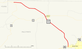
State Highway 337, abbreviated SH 337, is a 21.1-mile (33.957 km) state highway in the U.S. state of Texas. The highway begins at a junction with State Highway 16 (SH 16) and heads east to a junction with US 180 in Mineral Wells.
History
SH 337 was originally designated in 1940 as a route from SH 78 north of Bailey to SH 34. That route was transferred to FM 68 in 1942. It was then not designated, but signed in 1955 over FM 1077 from Plains to the New Mexico State line. In 1963, this route was transferred to US 82. SH 337 was again designated in 1963 to serve as a route between SH 16 and Mineral Wells.[1]
Route description
SH 337 begins at a junction with SH 16. It heads east from this junction to an intersection with SH 254 in Graford. SH 337 reaches its eastern terminus at US 181 in Mineral Wells.[1][2]
Junction list
The entire route is in Palo Pinto County.
| Location | mi | km | Destinations | Notes | |
|---|---|---|---|---|---|
| | 0.0 | 0.0 | Western terminus | ||
| Graford | 9.7 | 15.6 | |||
| Mineral Wells | 21.1 | 34.0 | Eastern terminus | ||
| 1.000 mi = 1.609 km; 1.000 km = 0.621 mi | |||||
References
- 1 2 3 Transportation Planning and Programming Division (n.d.). "State Highway No. 337". Highway Designation Files. Texas Department of Transportation. Retrieved 2008-04-01.
- ↑ Google (2008-04-01). "overview map of SH 337" (Map). Google Maps. Google. Retrieved 2008-04-01.