Texas State Highway 36
| |||||||
|---|---|---|---|---|---|---|---|
 | |||||||
| Route information | |||||||
| Maintained by TxDOT | |||||||
| Length: | 343.1 mi[1] (552.2 km) | ||||||
| Existed: | 1919 – present | ||||||
| Major junctions | |||||||
| South end: |
| ||||||
|
| |||||||
| North end: |
| ||||||
| Highway system | |||||||
| |||||||

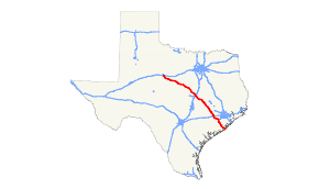
State Highway 36 runs from Freeport to Abilene. It was designated as The 36th Division Memorial Highway between Cameron and Sealy by the Texas Legislature in 1985.
History

SH 36 was originally proposed in 1919 as a route from Freeport to Goldthwaite. By 1926, the section from Temple to Goldthwaite had been SH 108A and SH 74, while SH 36 had been shortened to end in Temple. By 1933, SH 36 extended northwest to Hamilton. By 1935, the route was extended yet again to its current terminus in Abilene. By 1939, SH 36 had been rerouted over State Highway 221 south of Temple. It has run on its current course since 1946, with only minor route changes to bypass Brenham, Temple, and Freeport.

SH 36A was a spur route of SH 36 spltting off at Cameron and traveling east to Hearne. By 1926, the route had been renumbered as SH 69. It was instead redesignated on an alternate routing just south of Temple, serving the town of Heidenheimer. By 1936, the route had been renumbered State Highway 221.

SH 36B was a spur route of the original SH 36, splitting off at Lampasas and travelling southeast to Georgetown. By 1926, it had been renumbered as part of SH 74.
Proposed Future Alternate 36
A group calling itself the Highway 36A Coalition has proposed a new highway (tentatively titled Highway 36A) which would run between Highway 36 at Pleak and another planned route in Waller County (the proposed Prairie Parkway), ultimately connecting to Texas State Highway 6 north of Hempstead. According to the Coalition, the new highway would be limited access (along with improvements to the existing Highway 36 between Freeport and Pleak) and provide a western bypass of the Greater Houston area (as well as a new hurricane evacuation corridor).[2]
Major intersections
| County | Location | mi | km | Destinations | Notes |
|---|---|---|---|---|---|
| Brazoria | Freeport | South end of SH 288 overlap | |||
| Interchange; north end of SH 288 overlap | |||||
| | Bridge over Brazos River | ||||
| | |||||
| Brazoria | South end of FM 521 overlap | ||||
| North end of FM 521 overlap | |||||
| | |||||
| West Columbia | |||||
| Damon | |||||
| Fort Bend | Guy | ||||
| | |||||
| Needville | |||||
| | |||||
| Pleak | |||||
| Rosenberg | |||||
| South end of Alt. US 90 overlap | |||||
| North end of Alt. US 90 overlap | |||||
| | |||||
| Austin | Wallis | ||||
| South end of FM 1093 overlap | |||||
| | North end of FM 1093 overlap | ||||
| Sealy | |||||
| I-10 exit 720 | |||||
| | |||||
| | |||||
| Bellville | |||||
| South end of SH 159 overlap | |||||
| traffic circle around Austin County Courthouse | |||||
| North end of SH 159 overlap | |||||
| | Interchange | ||||
| | Hall Road | interchange | |||
| | |||||
| Washington | Brenham | ||||
| interchange; south end of US 290 overlap; south end of freeway | |||||
| Lubbock Street / Industrial Boulevard | Northbound exit and southbound entrance | ||||
| Old Mill Creek Road | |||||
| interchange; north end of US 290 overlap; north end of freeway | |||||
| Interchange; no southbound entrance | |||||
| | |||||
| Quarry | |||||
| Burleson | Somerville | ||||
| Lyons | South end of FM 60 overlap | ||||
| North end of FM 60 overlap | |||||
| | |||||
| Caldwell | |||||
| | |||||
| Milam | Milano | South end of US 79 / US 190 overlap, future I-14 | |||
| North end of US 79 overlap | |||||
| | South end of US 77 overlap | ||||
| | |||||
| Cameron | North end of US 77 overlap | ||||
| | |||||
| Pettibone | |||||
| Buckholts | South end of FM 1915 overlap | ||||
| North end of FM 1915 overlap | |||||
| Bell | Rogers | south end of FM 2184 overlap | |||
| north end of FM 2184 overlap | |||||
| | |||||
| | Interchange; no direct southbound exit (signed at FM 93) | ||||
| | Interchange | ||||
| | |||||
| | |||||
| Temple | Interchange; south end of Loop 363 overlap | ||||
| interchange; south end of freeway | |||||
| Access to Scott & White Memorial Hospital | |||||
| 57th Street / Thornton Lane | |||||
| North end of US 190 overlap, future I-14; I-35 exit 299 | |||||
| Wildflower Lane | Southbound exit only | ||||
| interchange; north end of freeway | |||||
| North end of Loop 363 overlap | |||||
| Interchange | |||||
| | |||||
| Coryell | | ||||
| | |||||
| Flat | |||||
| | |||||
| Gatesville | |||||
| Interchange | |||||
| | |||||
| | Interchange | ||||
| | |||||
| | |||||
| Jonesboro | |||||
| Hamilton | |||||
| Hamilton | east end of SH 22 overlap | ||||
| west end of SH 22 overlap | |||||
| Comanche | Siloam | ||||
| Gustine | |||||
| | |||||
| | east end of US 67/US 377 overlap | ||||
| Comanche | |||||
| west end of US 67/ US 377 overlap | |||||
| | |||||
| | |||||
| Stag Creek | east end of FM 1477 overlap | ||||
| | west end of FM 1477 overlap | ||||
| Eastland | Chuckville | ||||
| Rising Star | |||||
| | |||||
| | |||||
| | east end of FM 374 overlap | ||||
| | west end of FM 374 overlap | ||||
| Callahan | Cross Plains | ||||
| | |||||
| Rowden | |||||
| | |||||
| Denton | |||||
| | |||||
| | |||||
| | |||||
| Taylor | Abilene | ||||
| interchange | |||||
1.000 mi = 1.609 km; 1.000 km = 0.621 mi
| |||||
References
- ↑ Texas Department of Transportation,
- ↑ http://www.36acoalition.org/ Highway 36A Coalition