Texas State Highway 43
| ||||
|---|---|---|---|---|
 | ||||
| Route information | ||||
| Maintained by TxDOT | ||||
| Length: | 85.764 mi[1] (138.024 km) | |||
| Existed: | by 1933 – present | |||
| Major junctions | ||||
| South end: |
| |||
| North end: |
| |||
| Highway system | ||||
| ||||
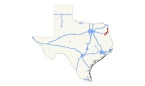
State Highway 43 (SH 43) is a Texas state highway that runs from Henderson to Atlanta.
Previous routes

SH 43 was originally proposed in 1919 to connect Longview to Rusk via Henderson. By 1922, the proposed route had been readjusted to extend farther west to Palestine and north to the Oklahoma border via Daingerfield. By 1933, the route had been further changed. The section from Henderson to Longview was transferred to SH 26, with the route now traveling northeast from Henderson to Caddo Lake Park north of Marshall. The section southwest of Palestine to Taylor, was renumbered from SH 43A. By 1933, SH 43 extended to Round Rock, replacing part of SH 2C. By 1935, the section from Round Rock to Palestine had been transferred to U.S. Highway 79. In 1942, another section was created from SH 49 to US 59 in Atlanta, replacing SH 300 and creating a gap in the route. In 1950, the section from Karnack to Caddo lake Park was transferred to FM 134. In 1967, the section from what was then FM 1915 to FM 134 was renumbered as Spur 449. Instead, SH 43 was rerouted on FM 1915, which was cancelled, closing the gap.

SH 43A was originally designated by 1922 as an alternate route to SH 43, splitting in Kilgore and running southwest through Palestine to Taylor. By 1926, the entire route south of Jacksonville had been transferred to the main route of SH 43. The section north of Jacksonville was cancelled. SH 43A was instead designated from Palestine to Henderson, replacing the original SH 43. By 1928, it was rerouted to end in Troup. By 1933, this route became extensions of SH 22 and SH 110.
Major junctions
| County | Location | mi | km | Destinations | Notes |
|---|---|---|---|---|---|
| Rusk | Henderson | Southern terminus | |||
| | |||||
| | |||||
| | |||||
| Tatum | |||||
| Panola | | ||||
| | |||||
| Harrison | | ||||
| | I-20 exit 614. | ||||
| Marshall | South end of US 59 overlap | ||||
| North end of US 59 overlap | |||||
| | |||||
| Karnack | |||||
| | South end of FM 134 overlap | ||||
| | North end of FM 134 overlap | ||||
| Marion | | South end of FM 805 overlap | |||
| | North end of FM 805 overlap | ||||
| Smithland | |||||
| | |||||
| Cass | | ||||
| Bivins | South end of brief FM 1841 overlap | ||||
| North end of brief FM 1841 overlap | |||||
| | |||||
| Atlanta | |||||
| Northern terminus; Future I-369 | |||||
1.000 mi = 1.609 km; 1.000 km = 0.621 mi
| |||||
References
- ↑ Transportation Planning and Programming Division (n.d.). "State Highway No. 43". Highway Designation Files. Texas Department of Transportation. Retrieved January 10, 2016.
