Texas State Highway 80
| ||||
|---|---|---|---|---|
 | ||||
| Route information | ||||
| Maintained by TxDOT | ||||
| Length: | 86.31 mi[1] (138.91 km) | |||
| Existed: | 1926 – present | |||
| Major junctions | ||||
| South end: |
 SH 123 at Karnes City SH 123 at Karnes City | |||
|
 I-35 in San Marcos I-35 in San Marcos | ||||
| North end: |
 RM 12 near San Marcos RM 12 near San Marcos | |||
| Highway system | ||||
| ||||


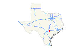
State Highway 80 (SH 80) is a state highway in the U.S. state of Texas that runs 83 miles (134 km) from Karnes City to San Marcos.[1]
History
The original highway was designated in 1926 from San Marcos to Luling. By 1928, SH 80 extended to Wimberley. By 1933, SH 80 had a planned extension south to Nixon. This absorbed all or portions of previously designated SH 29A and SH 21. By 1940, the route to Nixon had been completed, with the highway extended further south to Karnes City over former SH 112. In 1942, the section from Wimberley to San Marcos was transferred to Ranch to Market Road 12.
In 2010, RM 12 was shifted to an alignment south of San Marcos, and the SH 80 designation was extended through the city to a terminus with RM 12 west of the city.[1][2]
Major intersections
| County | Location | mi | km | Destinations | Notes | |||
|---|---|---|---|---|---|---|---|---|
| Karnes | Karnes City |     Bus. US 181 (E. Calvert Ave.) / SH 123 south (S. Badger Dr.) – Kenedy Bus. US 181 (E. Calvert Ave.) / SH 123 south (S. Badger Dr.) – Kenedy | Southern terminus; south end of SH 123 concurrency | |||||
| SH 123 north (N. Badger Dr.) – Stockdale | North end of SH 123 concurrency | |||||||
| |  FM 792 FM 792 | |||||||
| Helena |  FM 81 – Runge FM 81 – Runge | |||||||
| |  FM 1354 FM 1354 | |||||||
| |  FM 627 – Ecleto FM 627 – Ecleto | |||||||
| Gillett |   Spur 190 to FM 887 Spur 190 to FM 887 | |||||||
 SH 119 – Stockdale, Yorktown SH 119 – Stockdale, Yorktown | ||||||||
| Wilson |
No major junctions | |||||||
| Gonzales | Nixon |   US 87 / SH 97 south (Central Ave.) – Stockdale, Cuero US 87 / SH 97 south (Central Ave.) – Stockdale, Cuero | South end of SH 97 concurrency | |||||
 FM 1681 FM 1681 | ||||||||
| |  FM 1117 FM 1117 | |||||||
| | SH 97 north – Gonzales | North end of SH 97 concurrency | ||||||
| Leesville |  FM 1682 FM 1682 | |||||||
| |  FM 466 FM 466 | |||||||
| Belmont |   Alt. US 90 – Seguin, Gonzales Alt. US 90 – Seguin, Gonzales | |||||||
| Guadalupe | |  FM 1150 FM 1150 | ||||||
| Luling |  I-10 – San Antonio, Houston I-10 – San Antonio, Houston | I-10 exit 628. | ||||||
| Caldwell |  US 90 / US 183 south (E. Pierce St.) US 90 / US 183 south (E. Pierce St.) | South end of US 183 concurrency | ||||||
| US 183 north (N. Magnolia Ave.) | North end of US 183 concurrency | |||||||
| Stairtown |  FM 671 FM 671 | |||||||
| Fentress |  FM 20 FM 20 | |||||||
| |  SH 130 Toll – Seguin, Austin SH 130 Toll – Seguin, Austin | |||||||
| |  FM 1977 FM 1977 | |||||||
| |  FM 1979 FM 1979 | |||||||
| Martindale |  SH 142 east – Lockhart SH 142 east – Lockhart | South end of SH 142 concurrency | ||||||
 FM 1984 FM 1984 | ||||||||
| Hays | San Marcos |  SH 21 east (Airport Hwy.) – Bastrop SH 21 east (Airport Hwy.) – Bastrop | South end of SH 21 concurrency | |||||
| I-35 – San Antonio, Austin | I-35 exit 205; north end of SH 21/SH 142 concurrency. | |||||||
 Loop 82 north (N. LBJ Dr.) Loop 82 north (N. LBJ Dr.) | ||||||||
| Loop 82 south (N. Guadalupe St.) | ||||||||
 FM 2439 (W. Hopkins St.) FM 2439 (W. Hopkins St.) | ||||||||
| | RM 12 – Wimberley | Northern terminus | ||||||
1.000 mi = 1.609 km; 1.000 km = 0.621 mi
| ||||||||
References
- 1 2 3 Transportation Planning and Programming Division (n.d.). "State Highway No. 80". Highway Designation Files. Texas Department of Transportation. Retrieved August 27, 2013.
- ↑ Transportation Planning and Programming Division (2012). Texas County Map Book (PDF) (Map) (2012 ed.). 1:120,000. Texas Department of Transportation. p. 433. OCLC 867856197. Retrieved August 27, 2013.