Texiguat
| Texiguat | |
|---|---|
| Municipality | |
 Texiguat Location in Honduras | |
| Coordinates: 13°39′N 87°1′W / 13.650°N 87.017°W | |
| Country | Honduras |
| Department | El Paraíso |
| Area | |
| • Total | 203 km2 (78 sq mi) |
| Population (2015) | |
| • Total | 8,791 |
| • Density | 43/km2 (110/sq mi) |
Texiguat (Spanish pronunciation: [teksiˈɣwat]) is a municipality in the Honduran department of El Paraíso.
Capital: Yuscarán | ||
| Municipalities | 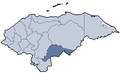 | |
Coordinates: 13°39′0″N 87°1′0″W / 13.65000°N 87.01667°W
This article is issued from Wikipedia - version of the 1/13/2016. The text is available under the Creative Commons Attribution/Share Alike but additional terms may apply for the media files.