A206 road
| |
|---|---|
|
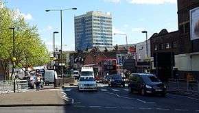
Woolwich High Street forms part of the A206 | |
| Route information | |
| Length: | 15 mi (24 km) |
| Major junctions | |
| West end: | Greenwich (51°28′26″N 0°01′16″W / 51.474°N 0.021°W) |
|
| |
| East end: | Greenhithe (51°26′53″N 0°16′44″E / 51.448°N 0.279°E) |
| Location | |
| Primary destinations: |
Woolwich Dartford Crossing |
| Road network | |
The A206 road links Greenwich with Greenhithe following the line of the River Thames. Today it is approximately 15 miles (24 km) in length, although the final section is a relatively new road. Its primary purpose is to link into the London Orbital motorway at the Dartford Crossing and is heavily used by lorries.
The main settlements along the route are Greenwich, Charlton, the Woolwich Free Ferry, Woolwich, West Heath, Belvedere, Erith, Dartford and Greenhithe.
External links
 Media related to A206 road (England) at Wikimedia Commons
A roads in Zone 2 of the Great Britain road numbering scheme | ||
|---|---|---|
Coordinates: 51°28′56″N 0°06′44″E / 51.48213°N 0.11235°E
This article is issued from Wikipedia - version of the 11/28/2016. The text is available under the Creative Commons Attribution/Share Alike but additional terms may apply for the media files.