Tregeare

Tregeare Methodist chapel
Tregeare (Cornish: Treger)[1] is a hamlet in the parish of Egloskerry in Cornwall, England, United Kingdom. To the east is the hill Tregearedown Beacon.[2]
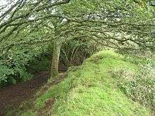
The outer defence of Tregeare Rounds
Tregeare Rounds is an Iron Age earthwork half a mile northeast of Pendoggett in the parish of St Kew. An area with a diameter of 500 ft is enclosed by two banks and ditches. As it is overlooked by higher ground to the northwest it may have been used as a cattle enclosure rather than a fortification.[3]
References
- ↑ Place-names in the Standard Written Form (SWF) : List of place-names agreed by the MAGA Signage Panel. Cornish Language Partnership.
- ↑ Ordnance Survey One-inch Map of Great Britain; Bodmin and Launceston, sheet 186. 1961
- ↑ Pevsner, N. (1970) Cornwall; 2nd ed., revised by Enid Radcliffe. Penguin; p. 223
Cornwall Portal | |
| Unitary authorities | |
| Major settlements |
|
| Rivers | |
| Topics | |
This article is issued from Wikipedia - version of the 9/6/2016. The text is available under the Creative Commons Attribution/Share Alike but additional terms may apply for the media files.