U.S. Route 302 in New Hampshire
| ||||
|---|---|---|---|---|
|
Map of northern New Hampshire with US 302 highlighted in red | ||||
| Route information | ||||
| Auxiliary route of US 2 | ||||
| Maintained by NHDOT | ||||
| Length: | 79.155 mi[1] (127.388 km) | |||
| Existed: | 1935[2] – present | |||
| Major junctions | ||||
| West end: |
| |||
| ||||
| East end: |
| |||
| Location | ||||
| Counties: | Grafton, Coos, Carroll | |||
| Highway system | ||||
| ||||

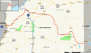
U.S. Route 302 (US 302) crosses the northern part of New Hampshire, entering the state by bridging the Connecticut River from Wells River, Vermont, following the Ammonoosuc River into the White Mountains, passing through Crawford Notch and following the Saco River out of the mountains to Fryeburg, Maine. US 302 serves as one of the few major highways that runs east–west in northern New England.
U.S. Route 302 is a spur of U.S. Route 2, but does not intersect its parent highway in New Hampshire.
Route description
US 302 enters the state of New Hampshire at a two-lane arch bridge over the Connecticut River beginning in Wells River, Vermont. It follows Central Street on a two-lane alignment, passing through Woodsville until it reaches NH 10 (Dartmouth College Highway), where it turns eastward.
US 302 follows the Ammonoosuc River through a mix of fields and forested land, passing through Bath as Lisbon Road and Lisbon as its Main Street. As it approaches Littleton, the road's name changes to Meadow Street and becomes a shopping strip just before crossing the river and interchanging with I-93. After a short stretch, the road meets Main Street (NH18) at a skewed intersection, defaulting onto Main Street and passing through the town's downtown.
The route intersects NH 116 and turns southward onto Cottage Street, immediately bridging the Ammonoosuc River once again, and passes through a residential area before turning eastward onto Bethlehem Road. The route passes under Interstate 93 again and passes through woodland, where it crosses I-93 for a third time at a second interchange, where also NH 18 and NH 116 depart to the south. US 302 then travels eastward through largely forested land, passing through Bethlehem and Twin Mountain (where it crosses U.S. Route 3), then turns southward as it passes through Crawford Notch State Park, bearing Crawford Notch Road as its name and paralleling the Saco River.
After turning eastward again, passing through Bartlett and intersecting NH 16, the road becomes White Mountain Highway and turns southward once more, passing Lower Bartlett and entering North Conway. The route follows Eastman Road south of North Conway, which it follows to its end at NH 113 (Main Street) after bridging the Saco River once again. US 302 turns east, passing through more forested land as it crosses the Maine state border, bound for Fryeburg a short stretch east of there.
History

Between 1922 and 1935, most of the current routing of US 302 from Portland, Maine west to its intersection with New Hampshire Route 18 in Littleton was designated as New England Interstate Route 18. The New England route designation was later removed and supplanted by the US 302 designation east of Littleton. West of Littleton, NH/VT Route 18 carried the designation north to US 2, which carried the designation west to Montpelier, Vermont.
US 302 today takes a more southerly path than the original Route 18. West of Littleton, it runs along parts of former New England Interstate Routes 10 and 25.
Major intersections
| County | Location[1][3] | mi[1][3] | km | Destinations | Notes |
|---|---|---|---|---|---|
| Grafton | Haverhill | 0.000 | 0.000 | Continuation from Vermont | |
| 0.224 | 0.360 | Village of Woodsville | |||
| 1.245 | 2.004 | Northern terminus of NH 10 | |||
| Bath | 3.812 | 6.135 | Western terminus of NH 112 | ||
| Lisbon | 12.960 | 20.857 | Western terminus of NH 117 | ||
| Littleton | 20.004– 20.152 | 32.193– 32.432 | Exit 42 on I-93 | ||
| 21.000 | 33.796 | Western end of concurrency with NH 18 | |||
| 21.556 | 34.691 | Western end of concurrency with NH 116 | |||
| 22.088 | 35.547 | Cottage Street | To | ||
| Bethlehem | 23.501– 23.850 | 37.821– 38.383 | Exit 40 on I-93; no eastbound access to I-93 north; no westbound access from I-93 south | ||
| 23.857 | 38.394 | Eastern end of concurrency with NH 18 / NH 116 | |||
| 26.672– 26.701 | 42.924– 42.971 | ||||
| Coos | Carroll | 34.796 | 55.999 | Village of Twin Mountain | |
| Carroll | Bartlett | 63.892 | 102.824 | Western end of concurrency with NH 16; village of Glen | |
| 65.026 | 104.649 | Northern terminus of NH 16A | |||
| 67.299 | 108.307 | Southern terminus of NH 16A | |||
| Conway | 71.981 | 115.842 | Eastern end of concurrency with NH 16; village of North Conway | ||
| 74.522 | 119.932 | Eastern terminus of NH 113 | |||
| 79.155 | 127.388 | Continuation into Maine | |||
1.000 mi = 1.609 km; 1.000 km = 0.621 mi
| |||||
References
- 1 2 3 Bureau of Planning & Community Assistance (February 20, 2015). "NH Public Roads". Concord, New Hampshire: New Hampshire Department of Transportation. Retrieved April 7, 2015.
- ↑ Droz, Robert V. U.S. Highways : From US 1 to (US 830). URL accessed 27 February 2006.
- 1 2 Bureau of Planning & Community Assistance (April 3, 2015). "Nodal Reference 2015, State of New Hampshire". New Hampshire Department of Transportation. Retrieved April 7, 2015.