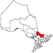
Unorganized North Nipissing District
| Unorganized North Nipissing District | |
|---|---|
| Unorganized area | |
| Nipissing, Unorganized, North Part | |
|
Eldee | |
 Unorganized North Nipissing | |
| Coordinates: 46°40′N 79°30′W / 46.667°N 79.500°WCoordinates: 46°40′N 79°30′W / 46.667°N 79.500°W | |
| Country |
|
| Province |
|
| District | Nipissing |
| Government | |
| • Federal riding | Nipissing—Timiskaming |
| • Prov. riding | Timiskaming—Cochrane, Nipissing |
| Area | |
| • Land | 3,755.97 km2 (1,450.19 sq mi) |
| Population (2011)[1] | |
| • Total | 1,853 |
| • Density | 0.5/km2 (1/sq mi) |
| Time zone | EST (UTC-5) |
| • Summer (DST) | EDT (UTC-4) |
| Area code(s) | 705 |
Unorganized North Nipissing District is an unorganized area in northeastern Ontario, Canada. It includes the unincorporated areas in northern Nipissing District north of the Mattawa River.
Communities
- Balsam Creek
- Eldee
- Redbridge
- Songis
- Thorne
- Tilden Lake
Demographics
| Canada census – Nipissing, Unorganized, North Part community profile | |||
|---|---|---|---|
| 2011 | 2006 | 2001 | |
| Population: | 1853 (3.1% from 2006) | 1798 (-3.1% from 2001) | 1856 (-7.9% from 1996) |
| Land area: | 3,755.97 km2 (1,450.19 sq mi) | 3,749.48 km2 (1,447.68 sq mi) | 3,630.64 km2 (1,401.80 sq mi) |
| Population density: | 0.5/km2 (1.3/sq mi) | 0.5/km2 (1.3/sq mi) | 0.5/km2 (1.3/sq mi) |
| Median age: | 43.8 (M: 44.2, F: 43.6) | 39.8 (M: 39.7, F: 40.0) | |
| Total private dwellings: | 1013 | 1078 | 962 |
| Median household income: | $53,506 | $43,289 | |
| References: 2011[2] 2006[3] 2001[4] | |||
Mother tongue (according to the Canada 2006 Census):[5]
- English as first language: 79.7%
- French as first language: 19.1%
- English and French as first language: 0%
- Other as first language: 1.1%
Population trend:[6]
- Population in 2011: 1853
- Population in 2006: 1798
- Population in 2001: 1856
- Population in 1996: 4149 (or 2016 when adjusted to 2001 boundaries)
- Population in 1991: 3911
See also
References
- ↑ "Nipissing, Unorganized, North Part census profile". 2011 Census of Population. Statistics Canada. Retrieved 2012-02-10.
- ↑ "2011 Community Profiles". Canada 2011 Census. Statistics Canada. July 5, 2013. Retrieved 2012-02-10.
- ↑ "2006 Community Profiles". Canada 2006 Census. Statistics Canada. March 30, 2011. Retrieved 2012-02-10.
- ↑ "2001 Community Profiles". Canada 2001 Census. Statistics Canada. February 17, 2012. Retrieved 2012-02-10.
- ↑ Nipissing, Unorganized, North Part Census Profile (2006)
- ↑ Statistics Canada: 1996, 2001, 2006, 2011 census
 |
Temagami | Unorganized West Timiskaming | Ottawa River |
 |
| Unorganized North Sudbury | |
Ottawa River / | ||
| ||||
| | ||||
| West Nipissing, Nipissing 10 | North Bay, East Ferris, Bonfield, Calvin | Mattawan |
This article is issued from Wikipedia - version of the 5/27/2015. The text is available under the Creative Commons Attribution/Share Alike but additional terms may apply for the media files.
