Vytina
| Vytina Βυτίνα | |
|---|---|
 | |
 Vytina | |
|
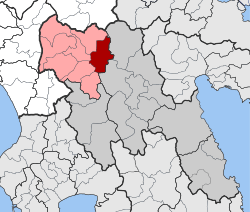
Location within the regional unit  | |
| Coordinates: 37°40′N 22°11′E / 37.667°N 22.183°ECoordinates: 37°40′N 22°11′E / 37.667°N 22.183°E | |
| Country | Greece |
| Administrative region | Peloponnese |
| Regional unit | Arcadia |
| Municipality | Gortynia |
| • Municipal unit | 139.3 km2 (53.8 sq mi) |
| Elevation | 1,036 m (3,399 ft) |
| Population (2011)[1] | |
| • Municipal unit | 1,116 |
| • Municipal unit density | 8.0/km2 (21/sq mi) |
| Time zone | EET (UTC+2) |
| • Summer (DST) | EEST (UTC+3) |
| Postal code | 220 10 |
| Area code(s) | 27950 |
| Website | www.dimosvitinas.gr |

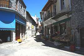
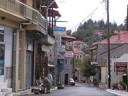
Vytina (Greek: Βυτίνα) is a mountain village and a former municipality in Arcadia, Peloponnese, Greece. It is considered a traditional settlement. Since the 2011 local government reform it is part of the municipality Gortynia, of which it is a municipal unit.[2] The municipal unit has an area of 139.309 km2.[3] The seat of the municipality was the village Vytina. The village is located at the foot of the mountain range Mainalo. The area produces marble, a variation called the Black of Vytina. Vytina is 10 km east of Levidi, 15 km northeast of Dimitsana and 24 km northwest of Tripoli. The Greek National Road 74 (Tripoli - Pyrgos) passes through Vytina. The ancient Arcadian city Methydrion was located near Vytina.
Subdivisions
The municipal unit Vytina is subdivided into the following communities (constituent villages in brackets):
- Elati
- Kamenitsa (Kamenitsa, Karvouni)
- Lasta (Lasta, Agridaki)
- Magouliana (Magouliana, Pan)
- Nymfasia
- Pyrgaki (Pyrgaki, Methydrio)
- Vytina (Vytina, Moni Panagias Kernitsis)
Population history
| Year | Village | Community | Municipal unit |
|---|---|---|---|
| 1981 | - | 876 | - |
| 1991 | 824 | - | 1,993 |
| 2001 | 885 | 999 | 2,012 |
| 2011 | 652 | 666 | 1,116 |
People
The father of the historian Constantine Paparrigopoulos, Dimitrios Paparrigopoulos was born in Vytina. Other important Vytiniots include the jurist Vasileios Oikonomidis, the provost marshal Ioannis Dimakopoulos, the iconographer Othon Giavopoulos and Kollias Vytiniotis.
See also
References
- ↑ "Απογραφή Πληθυσμού - Κατοικιών 2011. ΜΟΝΙΜΟΣ Πληθυσμός" (in Greek). Hellenic Statistical Authority.
- ↑ Kallikratis law Greece Ministry of Interior (Greek)
- ↑ "Population & housing census 2001 (incl. area and average elevation)" (PDF) (in Greek). National Statistical Service of Greece.
External links
- GTP - Vytina Municipality
- Vytina Village
- Black of Vytina
- Black of Vytina - Marbleguide
- Arcadia - Vytina
 |
Kleitor | Levidi |  | |
| Lagkadia | |
Levidi | ||
| ||||
| | ||||
| Dimitsana | Trikolonoi | Falanthos |