Walbundrie
| Walbundrie New South Wales | |
|---|---|
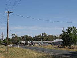 Walbundrie, looking south down the Corowa road. The intersection shown leads to the neighbouring town of Rand. | |
  Walbundrie | |
| Coordinates | 35°41′0″S 146°43′0″E / 35.68333°S 146.71667°ECoordinates: 35°41′0″S 146°43′0″E / 35.68333°S 146.71667°E |
| Population | 190 (2006 census)[1] |
| Postcode(s) | 2642 |
| Elevation | 151 m (495 ft) |
| Location | |
| LGA(s) | Greater Hume Shire Council |
| County | Hume |
| State electorate(s) | Albury |
| Federal Division(s) | Riverina |
Walbundrie /wɒlˈbʌndri/ is a village in the eastern Riverina district of New South Wales, Australia. The village is located 546 kilometres (339 mi) south-west of the state capital, Sydney and 335 kilometres (208 mi) north of Melbourne. Situated on the bank of the Billabong Creek, at the 2006 census, Walbundrie had a population of 190.[1] Walbundrie is in the Greater Hume Shire local government area. Billabong Creek passes immediately south of the town.
Piney Range Post Office opened on 1 March 1869 and was renamed Walbundrie later that month.[2]
The major industry in and around Walbundrie is agriculture, including grain production and wool growing. Australian rules football is the most popular sport.
Gallery
 Entering Walbundrie
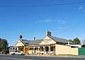 Walbundrie Hotel
References
- 1 2 Australian Bureau of Statistics (25 October 2007). "Walbundrie (State Suburb)". 2006 Census QuickStats. Retrieved 25 October 2007.
- ↑ Premier Postal History, Post Office List, retrieved 11 June 2009
External links
 Media related to Walbundrie at Wikimedia Commons
- Greater Hume Shire Council - Official site