Wallacea

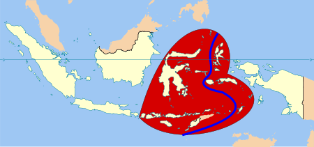
Wallacea is a biogeographical designation for a group of mainly Indonesian islands separated by deep water straits from the Asian and Australian continental shelves. Wallacea includes Sulawesi, the largest island in the group, as well as Lombok, Sumbawa, Flores, Sumba, Timor, Halmahera, Buru, Seram, and many smaller islands.
The islands of Wallacea lie between Sundaland (the Malay Peninsula, Sumatra, Borneo, Java, and Bali) to the west, and Near Oceania including Australia and New Guinea to the south and east. The total land area of Wallacea is 347,000 km².
| Sulawesi 6 provinces |
North Maluku, including Halmahera |
| Maluku, excluding Aru Islands | |
| West Nusa Tenggara (Lombok, Sumbawa) | East Nusa Tenggara, including Komodo, Flores, Sumba, West Timor East Timor (independent) |

Geography
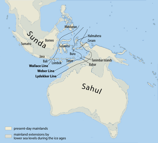
The boundary between Sundaland and Wallacea follows the Wallace Line, named after the naturalist Alfred Russel Wallace who noted the differences in mammal and bird fauna between the islands either side of the line. The islands of Sundaland to the west of the line, including Sumatra, Java, Bali, and Borneo, share a mammal fauna similar to that of East Asia, including tigers, rhinoceros, and apes, whereas those from Lombok and eastward are mostly populated by marsupials and birds similar to those in Australasia. Sulawesi shows signs of both.[1]
During the ice ages, sea levels were lower, exposing the Sunda shelf that links the islands of Sundaland to one another and to Asia,[2] and allowed Asian land animals to inhabit these islands. The islands of Wallacea have few land mammals, land birds, or freshwater fish of continental origin, who find it difficult to cross open ocean. Many bird, reptile, and insect species were better able to cross the straits, and many such species of Australian and Asian origin are found there. Wallacea's plants are predominantly of Asian origin, and botanists include Sundaland, Wallacea, and New Guinea as the floristic province of Malaya.
Similarly, Australia and New Guinea to the east are linked by a shallow continental shelf, and were linked by a land bridge during the ice ages, forming a single continent that scientists variously call Australia-New Guinea, Meganesia, or Sahul. Consequently, Australia, New Guinea, and the Aru Islands share many marsupial mammals, land birds, and freshwater fish that are not found in Wallacea.[3]
The line dividing Wallacea from Australia–New Guinea is called Lydekker's Line. The Philippines is usually considered a separate region from Wallacea.[4] The Weber Line is the midpoint where Asian and Australian fauna and flora are approximately equally represented, and follows the deepest straits traversing the Indonesian Archipelago.
Biota and conservation issues

Although the distant ancestors of Wallacea's plants and animals may have been from Asia or Australia-New Guinea, Wallacea is home to many endemic species. There is extensive autochthonous speciation and proportionately large numbers of endemics; it is an important contributor to the overall mega-biodiversity of the Indonesian archipelago.[5] Because many of the islands are separated from one another by deep water, there is tremendous species diversity among the islands as well.
Fauna species include the endemic anoa (dwarf buffalo) of Sulawesi and the babirusa (deer pig). Maluku shows a degree of species similarity with Sulawesi but with fewer flora and fauna. Smaller mammals including primates are common. Seram is noted for its butterflies and birdlife including the Amboina king parrot.
Wallacea was originally almost completely forested, mostly tropical moist broadleaf forests, with some areas of tropical dry broadleaf forest. The higher mountains are home to montane and subalpine forests, and mangroves are common in coastal areas. According to Conservation International, Wallacea is home to over 10,000 plant species, of which approximately 1500 (15%) are endemic.
Endemism is higher among terrestrial vertebrate species; of 1142 species found there, almost half (529) are endemic. 45% of the region retains some sort of forest cover, and only 52,017 km², or 15 percent, is in pristine state. Of Wallacea's total area of 347,000 km², about 20,000 km² are protected.
Wallacea is home to 82 threatened and six critically endangered species of terrestrial vertebrates.
Ecoregions
Tropical and subtropical moist broadleaf forests
- Banda Sea Islands moist broadleaf forests (Kai Islands, Tanimbar Islands)
- Buru rain forests (Buru)
- Halmahera rain forests (Halmahera, Morotai, Obi Islands, Bacan Island)
- Seram rain forests (Seram, Ambon Island, Saparua)
- Sulawesi lowland rain forests (Sulawesi, Banggai Islands, Sula Islands, Sangihe Islands, Talaud Islands)
- Sulawesi montane rain forests (Sulawesi)
Tropical and subtropical dry broadleaf forests
- Lesser Sundas deciduous forests (Lombok, Sumbawa, Komodo, Flores, Alor)
- Sumba deciduous forests (Sumba)
- Timor and Wetar deciduous forests (Timor, Barat Daya Islands, Banda Islands, Babar Island, Leti Islands)
Distribution between Asia and Australasia
Australia may be isolated by sea, but technically through Wallacea it can be zoologically extended. An example of evidence for when Wallacea formed exists at the Bluff Downs fossil site in northern Australia. Remains of basaltic lava show past oceanic subduction as Australia ploughed north through the Pacific. At the site, one of the earliest Australian rodent fossils has been found. Australia's rodents make up much of the continent's placental mammal fauna and include various species from stick-nest rats, hopping mice, and even giant beaver rats. Other mammals invaded west. Two species of cuscus from Sulawesi are among the most primitive possums in the world and the only marsupials in Asia.
Birds have expanded their range to and from Australia. Crows and shrikes invaded south into New Guinea and some into the Australian continent. Bustards and megapodes must have somehow colonized Australia. Cockatiels similar to those from Australia inhabit Komodo Island in Wallacea.
A few species of Eucalyptus, a predominant genus of trees in Australia, are found in Wallacea: Eucalyptus deglupta on Sulawesi, and E. urophylla and E. alba in East Nusa Tenggara.[6]
Notes
- ↑ Wallace, Alfred Russel (1869), The Malay Archipelago, pp. 25–29, retrieved 22 Jan 2013
- ↑ http://www.fieldmuseum.org/research_collections/zoology/zoo_sites/seamaps/mapindex1.htm Pleistocene Sea Level Maps
- ↑ http://actazool.nhmus.hu/48Suppl2/newwallace.pdf
- ↑ http://actazool.nhmus.hu/48Suppl2/newwallace.pdf
- ↑ http://www.irgltd.com/Resources/Publications/ANE/2004-02%20Indonesia%20Biodiversity%20and%20Tropical%20Forest.pdf page 3-2
- ↑ Irfan Budi Pramono and Ag. Pudjiharta (1996). "Research Experiences on Eucalyptus in Indonesia," in Reports submitted to the regional expert consultation on eucalyptus, Vol. II. Food and Agriculture Organization, Regional Office for Asia and the Pacific, Bangladesh.
References
- Abdullah MT. (2003). Biogeography and variation of Cynopterus brachyotis in Southeast Asia. PhD thesis. University of Queensland, St Lucia, Australia.
- Corbet, GB, Hill JE. (1992). The mammals of the Indomalayan region: a systematic review. Oxford University Press, Oxford.
- Hall LS, Gordon G. Grigg, Craig Moritz, Besar Ketol, Isa Sait, Wahab Marni and M.T. Abdullah. (2004). Biogeography of fruit bats in Southeast Asia. Sarawak Museum Journal LX(81):191–284.
- Wilson DE, Reeder DM. (2005). Mammal species of the world. Smithsonian Institution Press, Washington DC.
External links
- Conservation International: Wallacea
- Too Many Lines; The Limits of the Oriental and Australian Zoogeographic Regions George Gaylord Simpson, Proceedings of the American Philosophical Society, Vol. 121, No. 2 (Apr. 29, 1977), pp. 107–120
- Wallacea Research Group
- map of Wallace's, Weber's and Lydekker's lines