Wamp'una
For the Quechua variety called Wamp'una, see Quechuan languages.
| Wamp'una | |
|---|---|
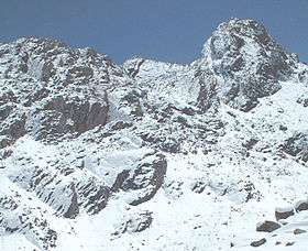 Wamp'una with entrance to Qaqa Mach'ay at left centre | |
| Highest point | |
| Elevation | 5,000 m (16,000 ft) |
| Coordinates | 12°26′02″S 75°40′03″W / 12.43389°S 75.66750°WCoordinates: 12°26′02″S 75°40′03″W / 12.43389°S 75.66750°W [1] |
| Geography | |
 Wamp'una Peru | |
| Location | Peru, Lima Region |
| Parent range | Andes, Cordillera Central |
Wamp'una (Quechua wamp'u boat, -na a suffix,[2] also spelled Huampuna) is a mountain in the Cordillera Central in the Andes of Peru, about 5,000 metres (16,404 ft) high. It contains one of the highest surveyed caves in the word, Qaqa Mach'ay.[3] Wamp'una is located in the Lima Region, Yauyos Province, on the border of the districts of Huantán and Laraos. It lies southwest of T'uruyuq, southeast of the lake named Pumaqucha.[4] It is situated on the southern border of the Nor Yauyos-Cochas Landscape Reserve.[5]
See also
References
- ↑ mapcarta.com "Cerro Huampuna", retrieved on September 22, 2013
- ↑ Teofilo Laime Ajacopa, Diccionario Bilingüe Iskay simipi yuyayk'ancha, La Paz, 2007 (Quechua-Spanish dictionary)
- ↑ members.shaw.ca Some Cave Statistics
- ↑ escale.minedu.gob.pe - UGEL map of the Yauyos Province (Lima Region)
- ↑ ParksWatch, Park Profile - Peru Nor Yauyos – Cochas Landscape Reserve, p. 6
This article is issued from Wikipedia - version of the 5/24/2016. The text is available under the Creative Commons Attribution/Share Alike but additional terms may apply for the media files.