Weald Country Park

Weald Country Park is a 700-year-old,[1] 500 acre (2 km²) country park in South Weald[2] in the borough of Brentwood in the English county of Essex. It is on the north-east fringe of Greater London.
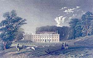
Weald manor, parts of which dated to the 16th century, was bought by Sir Anthony Browne in 1547 and he died at Weald Hall in 1567.[3] In 1685, Erasmus Smith bought it from Sir William Scroggs.[4] The current layout is largely the result of landscaping carried out in the naturalistic manner of Capability Brown for Hugh Smith, lord of the manor from 1732 to 1745.[5] In 1752, the estate was sold to Thomas Tower of Iver in Buckinghamshire, a lawyer and MP for Wareham in Dorset. Christopher Tower succeeded as the owner in 1778 and immediately commissioned Robert Adam to design a new dining room. On his death in 1810, his son, Christopher Thomas Tower, succeeded until 1867; he enlarged the estate and enclosed some commons as "waste". Weald Hall, with 800 acres (3.2 km2) in 1841, was let to farmers in the 19th century[6] sold by another C. T. Tower in 1946, when the estate was broken up though part of the park was retained for the Green Belt of London. Some remnants remain of the Hall, which was demolished in 1950–51[7] due to war damage, in particular some steps leading to what used to be a folly in the park. The 16th-century lodge miscalled "Queen Mary's Chapel" because it was locally rumoured to have been used by Queen Mary for quiet prayer and contemplation, which used to be enclosed within Weald Hall's walled kitchen garden, still remains at the edge of the park. A very large (2.8 by 4.8 metres) painting of Weald Hall hung in a dining room at nearby Brentwood School. Depicting the house and park before 18th Century alterations it is attributed to Dutch painter Jan Griffier the Elder (1652-1718). The school, which was founded by a former owner of the Hall, Sir Anthony Browne, sold the painting to a private collector at Sotheby's in November 1985.
The park is now managed by Essex County Council.
2012 Olympic Games
The park was due to be the venue for the mountain biking events at the 2012 Summer Olympics. However, following a visit by inspectors from the Union Cycliste Internationale, the site was considered insufficiently challenging for international competition and a new venue was sought.[8] Hadleigh Country Park was chosen as the replacement venue.[9]
References
- ↑ The manor of Weald descended in the barony of Valognes until the 13th century, when the barony was divided among coheirs. ('North Weald Bassett: Manors', A History of the County of Essex: Volume 4: Ongar Hundred (1956), pp. 286-290 Accessed: 25 September 2008). South Weald belonged to the Abbey of Waltham Holy Cross, until the Dissolution of the Monasteries (in this case, 1540).
- ↑ Weald (walda in Domesday) denotes forest land; by 1777 there was apparently no woodland left apart from Weald Hall Coppice, which still survived in 1954. ('North Weald Bassett: Introduction', A History of the County of Essex: Volume 4: Ongar Hundred (1956), pp. 284-286 Accessed: 25 September 2008
- ↑ 'Parishes: South Weald', A History of the County of Essex: Volume 8 (1983), pp. 74-90. Accessed 25 September 2008.
- ↑
- Barnard, Toby (2004). "Smith, Erasmus". Oxford Dictionary of National Biography. (subscription or UK public library membership required)
- ↑ Hugh Smith was an ancestor of the Earls of Derby.
- ↑ Victoria County History, ibid.
- ↑ Howard Colvin, A Biographical Dictionary of British Architects, 1600-1840, 3rd ed. 1995, s.v. "Adam, Robert"; some interior fittings were salvged by Crowther of Syon Lodge: a doorcase was installed in the restoration of Tryon Palace, New Bern, North Carolina (John Harris, Moving Rooms: The Trade in Architectural Salvages (Yale University Press) 2007, Appendix 3.
- ↑ Mountain bike course 'too easy', BBC Sport, Friday, 1 February 2008
- ↑ BBC. (2008-06-06). Look East: Biking back on the agenda. Retrieved 2008-06-10.
External links
| Wikimedia Commons has media related to Weald Country Park. |
- History of Weald Park
- Visitor details from Essex County Council
- Page from Brentwood Borough Council
- Panoramic view
Coordinates: 51°37′39″N 0°15′55″E / 51.62744°N 0.26539°E