West Crater
| West Crater | |
|---|---|
 | |
| Highest point | |
| Elevation | 4,360 ft (1,330 m) |
| Coordinates | 45°52′26″N 122°05′01″W / 45.8740030°N 122.0836985°WCoordinates: 45°52′26″N 122°05′01″W / 45.8740030°N 122.0836985°W [1] |
| Geography | |
| Location | Skamania County, Washington, U.S. |
| Parent range | Cascade Range |
| Topo map | Lookout Mountain |
| Geology | |
| Age of rock | Holocene |
| Mountain type | lava dome |
| Volcanic arc | Cascade Volcanic Arc |
| Last eruption | 5750 BCE (?) |
West Crater is a small andesitic lava dome with associated lava flows in southern Washington, United States.[2]
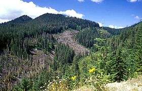
West Crater is a little-known Quaternary volcanic field in the southern Cascades of Washington between Mount St. Helens and Mount Hood. West Crater itself, seen here from the NE, is an andesitic dome with two small lava flows, one of which forms the bare area at the right center. The 290-m-high dome was formed about 8060 years ago on the floor of a cirque carved into older Tertiary volcanic rocks. The West Crater volcanic field consists of a series of small shield volcanoes and cinder cones along a NW-SE zone.
See also
References
- ↑ "West Crater". Geographic Names Information System. United States Geological Survey. Retrieved 2009-05-27.
- ↑ "West Crater". Global Volcanism Program. Smithsonian Institution. Retrieved 2009-05-27.
External links
This article is issued from Wikipedia - version of the 5/17/2016. The text is available under the Creative Commons Attribution/Share Alike but additional terms may apply for the media files.