Westelijke Polders
| Westelijke Polders | |
|---|---|
| Resort | |
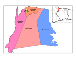
 Map showing the resorts of Nickerie District. | |
| Country |
|
| District | Nickerie District |
| Area | |
| • Total | 1,168 km2 (451 sq mi) |
| Population (2012) | |
| • Total | 8,616 |
| • Density | 7.4/km2 (19/sq mi) |
| Time zone | AST (UTC-3) |
Westelijke Polders is a resort in Suriname, located in the Nickerie District. Its population at the 2012 census was 8,616.[1]
Its Dutch placename (in English 'western polders') reflects Suriname's colonial past.
Its western boundary is the Courantyne River, between Suriname and Guyana.
References
Coordinates: 5°21′21″N 57°14′08″W / 5.3558°N 57.2355°W
This article is issued from Wikipedia - version of the 4/3/2014. The text is available under the Creative Commons Attribution/Share Alike but additional terms may apply for the media files.
