Woleai
|
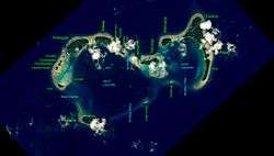
NASA picture of Woleai Atoll | |
 Woleai | |
| Geography | |
|---|---|
| Location | North Pacific |
| Coordinates | 7°22′N 143°54′E / 7.367°N 143.900°E |
| Archipelago | Caroline |
| Total islands | 18 |
| Area | 4.5 km2 (1.7 sq mi) |
| Highest elevation | 2 m (7 ft) |
| Administration | |
| Demographics | |
| Population | 1081 (2000) |
| Ethnic groups | Micronesian |

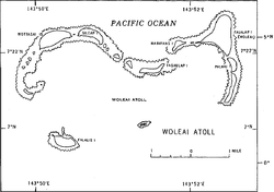
Woleai, also known as Oleai,[1] is a coral atoll of twenty-two islands in the eastern Caroline Islands in the Pacific Ocean, and forms a legislative district in the Yap State in the Federated States of Micronesia and is located approximately 57 kilometres (35 mi) west-northwest of Ifalik and 108 kilometres (67 mi) northeast of Eauripik. Woleai is also the name of the largest of the islets constituting the atoll, lying to the northeast.
The population of the atoll was 1,081 in 2000,[2] on an area of 4.5 km2.
Geography
The islands constitute a double atoll forming the number eight, with a total length of 11.5 kilometres (7.1 mi) and up to 7 kilometres (4.3 mi) wide; however, most of reef on the southern rim is submerged or poorly developed. The northern and eastern rims have several relatively large islets. The western lagoon is deeper and larger than its eastern counterpart. Both components are part of the same seamount. The total land area for both components combined is only 4.5 square kilometres (1.7 sq mi).[3]
History
Woleai is culturally unique because a script was discovered to be in use among some speakers of the Woleaian language in 1913. As with all of the Caroline Islands, sovereignty passed to the Empire of Germany in 1899. The atoll came under the control of the Empire of Japan after World War I, and was subsequently administered under the South Pacific Mandate.
In 1944, as the Allied forces closed in on the Mariana Islands, Woleai was heavily fortified by a contingent of 6,426 troops from the Imperial Japanese Army’s IJA 50th Independent Mixed Brigade and Imperial Japanese Navy’s 44th Base Guard Unit and 216th Base Construction Unit. Wolfe Islet was completely leveled, and made into an airfield with a single 3,290 foot runway and 2,050 foot taxiway. A seaplane anchorage was also constructed off the south-west corner of Woleai Islet. The island and its military facilities were bombed on numerous occasions through the end of 1944 until the middle of 1945, driving its defenders underground, and isolating them from supplies or reinforcements. By the surrender of Japan, only 1,650 survivors remained, the rest having perished by starvation or disease. The survivors were recovered by USS Sloat (DE-245) on September 17, 1945.[4]
Following World War II, the atoll came under the control of the United States of America. It was administered as part of the Trust Territory of the Pacific Islands from 1947, and became part of the Federated States of Micronesia beginning 1979.
References
- Columbia Gazeteer of the World. Vol. 1, p. 900
- ↑ Report of the German South Pacific Expedition 1908-1910
- ↑ Yap State Census Report, 2000 (PDF)
- ↑ Oceandots at the Wayback Machine (archived December 23, 2010)
- ↑ http://www.desausa.org/images5/uss_sloat_de_245_woleai_surrender.htm Surrender of Woleai
External links
- Entry at Oceandots.com at the Wayback Machine (archived December 23, 2010)
- Pacific Wrecks
- Surrender of Woleai
- V6T Amateur Radio Woleai
