Xiangxi Tujia and Miao Autonomous Prefecture
| Xiangxi Prefecture 湘西州 | |
|---|---|
| Autonomous Prefecture | |
湘西土家族苗族自治州 Xiangxi Tujia and Miao Autonomous Prefecture | |
|
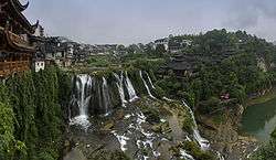
Panorama of Furong, a Tujia ancient town in Yongshun County | |
 Xiangxi Prefecture Location of Xiangxi Tujia and Miao Autonomous Prefecture in Hunan | |
| Coordinates: 28°19′N 109°44′E / 28.317°N 109.733°E | |
| Country | People's Republic of China |
| Province | Hunan |
| Area | |
| • Total | 15,486 km2 (5,979 sq mi) |
| Population (2004) | |
| • Total | 3,650,000 |
| Time zone | China Standard (UTC+8) |
Xiangxi Tujia and Miao Autonomous Prefecture (Chinese: 湘西土家族苗族自治州; pinyin: Xiāngxī Tǔjiāzú Miáozú Zìzhìzhōu) is an autonomous prefecture of the People's Republic of China. It is located in western Hunan province.[lower-alpha 1] It consists of 1 city, Jishou, and 7 counties: Baojing, Fenghuang, Guzhang, Huayuan, Longshan, Luxi, Yongshun.[lower-alpha 2] The capital is Jishou. Twenty-five nationalities gather here, of the total 2,480,000 population, 66.6 per cent are ethnic minorities, including 860,000 Tujia and 790,000 Miao.[1]
History
Xiangxi has a long history. The land was sparsely inhabited during the Shang Dynasty, through the Warring States period up to the era of the Sui dynasty and Tang Dynasty. It fell under the influence of the Chu state during the Warring tates era. Later, it became part of the Western and Eastern han dyansty. After the collapse of the Han dynasty, it became under the control of the Shu Dynasty during the Three Kingdoms Period of China. Then the area became a subject of the Jin Dynasty. When the Yuan Dynasty was established, the region became a part of the Hubei province. Soon later, Hubei and Hunan province became one single province called Huchang (湖广). The Ming dynasty reestablished the Xiangxi Autonomous Prefecture and attached it to Hunan province.
Upon the establishment of modern China, the national government gave the region autonomous status and county level status. This meant that the control of the provincial government had less control over the region compared to other counties.
Modern reforms
Ever since the reforms by Deng Xiaoping, the region has developed substantially. The introduction of a large nubmer of advanced production equipment and various types of automated production factories accelerated the growth of industries. In 2008, the total production value totlaed 22,666 billion yuan.
Crop Production
Agricultural products such as rice, wheat, corn, soybeans, electricity, cement, wood, cigarettes, fertilizers, yarn and cloth became primary products.
Places
| Place Name | Place Name (Chinese) | Pinyin | Miao Language transliteration | [2] Population |
Subdivisions[3] | ||||
|---|---|---|---|---|---|---|---|---|---|
| Subdistricts | Towns | Townships | Districts | Villages | |||||
| Xiangxi Tujia Miao Autonomous Zone | 湘西土家族 苗族自治州 |
Xiāngxī Tǔjiāzú Miáozú Zìzhìzhōu | 15462.30 | 7 | 69 | 89 | 183 | 1967 | |
| Jishou City | 吉首市 | Jíshǒu Shì | Jib Soud | 1062.46 | 4 | 5 | 7 | 38 | 138 |
| Luxi County | 泸溪县 | Lúxī Xiàn | Lioux Kid | 1568.65 | 8 | 7 | 16 | 134 | |
| Fenghuang County | 凤凰县 | Fènghuáng Xiàn | Jib Zhes | 1751.10 | 9 | 15 | 15 | 344 | |
| Huayuan County | 花垣县 | Huāyuán Xiàn | Jib Yox | 1111.12 | 8 | 10 | 19 | 288 | |
| Baojing COunty | 保靖县 | Bǎojìng Xiàn | Jib Yal | 1745.88 | 10 | 6 | 16 | 198 | |
| Guzhan County | 古丈县 | Gǔzhàng Xiàn | Bloud Nhol | 1286.23 | 6 | 6 | 18 | 140 | |
| Yongshun County | 永顺县 | Yǒngshùn Xiàn | Mongl Dongs | 3809.69 | 12 | 18 | 33 | 291 | |
| Longshan County | 龙山县 | Lóngshān Xiàn | Gheul Rongx | 3127.16 | 3 | 11 | 20 | 28 | 434 |
See also
- List of township-level divisions of Hunan
Notes
- ↑ Xiangxi literally means "Hunan west", Xiāng (湘) being an abbreviation for Hunan and xī (西) meaning "west".
- ↑ Until 1988, part of the area that is now the prefecture-level city of Zhangjiajie, specifically Dayong city and Sangzhi County, was part of the autonomous prefecture.
References
- ↑ Xiangxi city and Xiangxi River - Xiangxi Tujia-Miao Autonomous Prefecture Is Located in Northwestern Hunan Province.
- ↑ 湘西土家族苗族自治州国土资源局. 《湘西土家族苗族自治州土地利用总体规划(2006-2020年)》.
- ↑ 中华人民共和国民政部 (2014年8月). 《中国民政统计年鉴2014》. 中国统计出版社. ISBN 978-7-5037-7130-9. Check date values in:
|date=(help)
External links
Coordinates: 28°19′N 109°44′E / 28.317°N 109.733°E
