Yurihama, Tottori
| Yurihama 湯梨浜町 | |
|---|---|
| Town | |
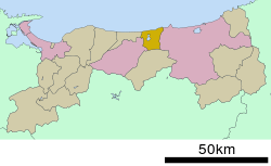
 Location of Yurihama in Tottori Prefecture | |
 Yurihama Location in Japan | |
| Coordinates: 35°29′N 133°52′E / 35.483°N 133.867°ECoordinates: 35°29′N 133°52′E / 35.483°N 133.867°E | |
| Country | Japan |
| Region |
Chūgoku San'in |
| Prefecture | Tottori Prefecture |
| District | Tōhaku |
| Area | |
| • Total | 77.94 km2 (30.09 sq mi) |
| Population (June 1, 2016) | |
| • Total | 16,437 |
| • Density | 211/km2 (550/sq mi) |
| Symbols | |
| • Tree | Nashi pear |
| • Flower | Touteiran |
| • Bird | Sankōchō |
| Time zone | Japan Standard Time (UTC+9) |
| City hall address |
19-1 Hisadome, Yurihama-chō, Tōhaku-gun, Tottori-ken 682-0723 |
| Website |
www |
Yurihama (湯梨浜町 Yurihama-chō) is a town located in Tōhaku District, Tottori Prefecture, Japan.
As of December 31, 2009, the town has an estimated population of 17,785 and a density of 228 persons per km2. The total area is 77.95 km2.
Yurihama was created on October 1, 2004, after a merger of the towns of Hawai and Tōgō, and the village of Tomari, all from Tōhaku District.
Yurihama is also well known for its hot springs near Lake Tōgō.
Surrounding municipalities
Places of note
- Enchoen Chinese Garden
- Fudō-taki (waterfall)
- Ueshi-jō (castle)
- Tōgo Onsen
- Hawai Onsen
- Shitori Shrine (shrine)
Sister city
-
 Hawaii County, Hawaii, United States (1996)
External links
 Media related to Yurihama, Tottori at Wikimedia Commons
- Yurihama official website (Japanese)
This article is issued from Wikipedia - version of the 7/23/2016. The text is available under the Creative Commons Attribution/Share Alike but additional terms may apply for the media files.