Zagore Beach

Location of Livingston Island in the South Shetland Islands.
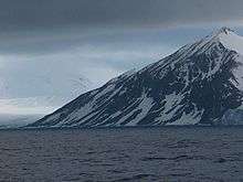
Zagore Beach from southwest.

Topographic map of Livingston Island, Greenwich, Robert, Snow and Smith Islands.
Zagore Beach (Zagorski Bryag \za-'gor-ski 'bryag\) faces False Bay on Livingston Island, Antarctica and extends for 4 km on the Rozhen Peninsula between Charity Glacier and the Ruen Icefall. The beach is surmounted by Canetti Peak (400 m) and MacKay Peak (approx 700 m). Surface area 220 hectares (540 acres).[1]
The beach is named after the historic region of Zagore situated south of the Balkan Mountains in Bulgaria.
Location
The midpoint of the beach is located at 62°42′46″S 60°19′23″W / 62.71278°S 60.32306°WCoordinates: 62°42′46″S 60°19′23″W / 62.71278°S 60.32306°W (Bulgarian mapping in 2005 and 2009).
Map
- L.L. Ivanov et al. Antarctica: Livingston Island and Greenwich Island, South Shetland Islands. Scale 1:100000 topographic map. Sofia: Antarctic Place-names Commission of Bulgaria, 2005.
Notes
- ↑ L.L. Ivanov. Antarctica: Livingston Island and Greenwich, Robert, Snow and Smith Islands. Scale 1:120000 topographic map. Troyan: Manfred Wörner Foundation, 2009. ISBN 978-954-92032-6-4
References
This article includes information from the Antarctic Place-names Commission of Bulgaria which is used with permission.
This article is issued from Wikipedia - version of the 11/21/2015. The text is available under the Creative Commons Attribution/Share Alike but additional terms may apply for the media files.