Þjófafoss
Coordinates: 64°3′25″N 19°52′1″W / 64.05694°N 19.86694°W
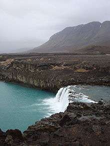
Þjófafoss and Búrfell, as seen from the Merkurhraun lava fields
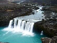
The view east from Merkurhraun showing Þjófafoss and Þjórsá.
Þjófafoss (Thjofafoss) is located on the river Þjórsá on the east side of the Merkurhraun lava fields in the south of Iceland, at the southwest tip of the hill Búrfell. A viewing point for the waterfall can be accessed by a gravel track that leads about 4 kilometres (2.5 mi) northwest from Route 26 or by a track that leads south from Route 32 past the hydroelectric power station Búrfellsstöð and Hjálparfoss.
See also
External links
- More travel information from enjoyiceland.is
- More images of Þjófafoss at the Flickr
- Photo from ipernity
This article is issued from Wikipedia - version of the 6/16/2013. The text is available under the Creative Commons Attribution/Share Alike but additional terms may apply for the media files.
