Abraham Lincoln Memorial Bridge
- The Abraham Lincoln Memorial Bridge can also refer to the Blair Bridge in Iowa and Nebraska. There is also a Lincoln Memorial Bridge in Vincennes, Indiana.
| Abraham Lincoln Memorial Bridge | |
|---|---|
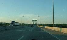
 Approaching the Abraham Lincoln Memorial Bridge from the south. | |
| Coordinates | 41°19′29″N 89°04′37″W / 41.3247°N 89.0769°WCoordinates: 41°19′29″N 89°04′37″W / 41.3247°N 89.0769°W |
| Carries |
Four lanes of |
| Crosses | Illinois River, IL 351, Illinois and Michigan Canal, Iowa Interstate Railroad, and Buzzi Unicem industrial rail lead (the former Illinois Central Railroad mainline). |
| Locale | LaSalle, Illinois and Oglesby, Illinois |
| Official name | Abraham Lincoln Memorial Bridge |
| Maintained by | Illinois Department of Transportation |
| ID number | 000050019120847 |
| Characteristics | |
| Design | Through arch |
| Total length | 2,170.8 metres (7,122.0 ft)[1] |
| Width | 4 traffic lanes, 82 ft (25 m)[2] |
| Longest span | 619.9 feet (189 m)[2] |
| Clearance above | 19.3 feet (5.88 m)[2] |
| History | |
| Opened | 1987 |
Abraham Lincoln Memorial Bridge in Illinois is a four-lane bidirectional road bridge that spans the Illinois River, Illinois Route 351, Illinois and Michigan Canal, and local roads and railroads. It carries Interstate 39 (I-39), a major north-south Interstate through central Illinois, and its U.S. Route counterpart, U.S. Route 51 (US 51).
Description
The bridge crosses the river between LaSalle and Oglesby, at river mile 225.8.[3] The structure comprises a main span over the river, flanked by 43 approach spans.It is named after Abraham Lincoln, the sixteenth president of the United States. The main span is a through-arch design, 620 feet (189.0 m) long. The clearance of this span over the river, from low steel of the bridge to normal water level in the pool below, is 66.0 feet (20.1 m).[3] With the approach spans, the total length of the structure is 7,120.8 feet (2,170.4 m).
History
The bridge was built in 1987 when I-39 was first extended south to what is now Illinois Route 251. The highway itself has since been extended all the way to the Bloomington–Normal.
See also
-
 Bridges portal
 -
 Illinois portal
 - List of crossings of the Illinois River
References
- ↑ Svirsky, Alexander. "Nationalbridges.com". Retrieved 2007-10-22.
- 1 2 3 Baughn, James; et al. (2005). "Historic Bridges of the Midwest". Retrieved 2006-01-18.
- 1 2 Map no. 89, Illinois Waterway Mile 225.1 to 228, U.S. Army Corps of Engineers (1998).

