Agdal Gardens

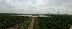
Panoramic view of agdal gardens

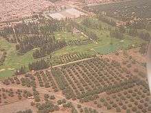
Aerial view

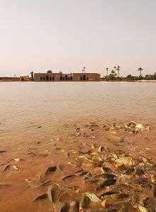
The Dar El Hana pavilion stands next to the Sahraj el-Hana.

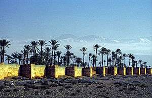
Wall around the gardens
The Agdal Gardens (or Aguedal Gardens) are botanical gardens of around 400 hectares (4.0 km2; 1.5 sq mi) in surface area, located to the south of Dar El Makhzen, the Royal Palace, and the medina in Marrakech, Morocco. Their name derives from the Berber language for "walled meadow". Extending for some 3 kilometres (1.9 mi), the gardens include groves of orange, lemon, fig, apricot and pomegranate trees in rectangular plots, linked by olive-lined walkways.
Together with the medina of Marrakech and the Menara Gardens, the Agdal Gardens were listed by UNESCO as a World Heritage Site in 1985.
History
The gardens were established in the 12th century by Abd al-Mu'min of the Almohad Caliphate. They served as an orchard.
They were renovated by the Saadi dynasty and then enlarged during the reign of Moulay Abderrahmane in the 19th century, when they were enclosed with pisé walls.
Irrigation System
The gardens are irrigated using a number of pools and ditches. A network of underground channels and ditches, known as khettera, bring water down from the High Atlas mountains many kilometres away, via Aghmat in the Ourika Valley to the south.
The Dar El Hana, a small pavilion or minzah, stands beside the largest pool, the Sahraj el-Hana (Tank of Health), which was used to train troops to swim. Sultan Mohammed IV died in the pool when his steam launch capsized there in 1873.[1] His successor, Sultan Moulay Hassan, housed his harem in another pavilion in the gardens, the Dar al Baida.
See also
Notes
- ↑ The Rough Guide to Morocco, p.370.
References
- Page at gardenvisit.com
- Footprint travel guides (text from Footprint Marrakech & the High Atlas Handbook: The Travel Guide, p. 102, Published by Footprint Travel Guides, 2001, ISBN 1-903471-12-5)
- Travelingo.org (text from The Rough Guide to Morocco, p. 370, Published by Rough Guides, 2001, ISBN 1-85828-601-8)
- UNESCO listing
- Richard Covington, The art and science of water, 2006, Saudi Aramco World
External links
Coordinates: 31°36′22″N 7°58′47″W / 31.6061°N 7.9797°W / 31.6061; -7.9797
|
|---|
|
| Subdivisions |
- Communes
- Mechouar Kasba
- Annakhil
- Gueliz
- Marrakech-Medina
- Menara
- Sidi Youssef Ben Ali
- Alouidane
- Harbil
- M'Nabha
- Ouahat Sidi Brahim
- Oulad Hassoune
- Ouled Dlim
- Agafay
- Ait Imour
- Loudaya
- Saada
- Sid Zouine
- Souihla
- Tassoultante
- Neighbourhoods
- Bab Ghmat
- Arset El Baraka
- Arset Moulay Bouaza
- Djane Ben Chogra
- Arset El Houta
- Bab Aylan
- Arset Sidi Youssef
- Derb Chtouka
- Bab Hmar
- Bab Agnaou
- Quartier Jnan Laafia
- Toureg
- Kasbah
- Mellah
- Arset El Maach
- Arset Moulay Moussa
- Riad Zitoun Jdid
- Kennaria
- Rahba Kedima
- Kaat Benahid
- Zaouiat Lahdar
- El Moukef
- Riad Laarous
- Assouel
- Kechich
- Douar Fekhara
- Arset Tihiri
- Sidi Ben Slimane El Jazouli
- Diour Jdad
- Rmila
- Zaouia Sidi Rhalem
- Kbour Chou
- Ain Itti
- Bab Doukkala
- El Hara
- Arset El Bilk
- Daoudiate
- Diour El Massakine
- Yamama
- Sidi Abbad
- Sakar
- Malizia
- Sidi Youssef Ben Ali
- Massima
- Hay Annahda
- Berradi
- Douar Lahna
- Touggana
- Lagouassem
- Lahebichate
|
|---|
|
| Landmarks |
- Squares and places
- Jemaa el-Fnaa
- El Mashwar
- El Moussalla
- Place Bab Doukkala
- Square Charles de Foucauld
- Place de la Liberté
- Place du 16 Novembre
- Place des Ferblantiers
- Place Sidi Ahmed El Kamel
- Place Youssef Ben Tachfine
- Place Mourabiten
- Square Bir Anzaran
- Places of worship
- Koutoubia Mosque
- Ben Youssef Medrassa
- Ben Youssef Mosque
- Kasbah Mosque: Moulay Alyazid Mosque
- Mansouria Mosque
- Barrima Mosque
- Mouassine Mosque
- Zaouia of Sidi Bel Abbes
- Zaouia of Muhammad al-Jazuli
- Zaouia of Sidi Youssef Ben Ali
- Sidi Moulay el Ksour Mosque
- Synagogue Beth-El
- Synagogue Salat el Azama
- Synagogue Salat Rabi Pinhasse
- Tombs and places of rest
- Saadian Tombs
- Mausoleum of Ahmed el-Mansour
- Koubba of Fatima Zohra
- Almoravid Koubba
- Koubba Cadi Ayyad
- Jewish Cemetery
- Sidi Abd el Aziz
- Sidi es Suhayli
- City walls and gates
- Bab Aghmat
- Bab Agnaou
- Bab Ahmar
- Bab al-Arissa
- Bab al-Arset ben Brahim
- Bab Aylen
- Bab Berrima
- Bab ech Charia
- Bab Debbagh
- Bab Doukkala
- Bab Fteuh
- Bab Hmar
- Bab Ighli
- Bab el Jédid
- Bab el Khémis
- Bab Ksiba
- Bab el Makhzen
- Bab Nkob
- Bab er Raha
- Bab al-Ra'is
- Bab er Rharaza
- Bab er Robb
- Bab Taghzout
- Landmarks
- El Badi Palace
- Royal Palace
- Bahia Palace
- Aïn Kassimou
- Museums
- Dar Si Saïd Museum
- Marrakech Museum
- Bert Flint Museum
- Islamic Art Museum
- Parks and gardens
|
|---|
|
| Economy | |
|---|
|
| Transport | |
|---|
|
| Education | |
|---|
|
| Sports | |
|---|
|
| History | |
|---|
|
| People |
- See Category:People from Marrakesh
|
|---|


 Media related to Agdal Gardens at Wikimedia Commons