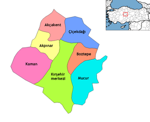
Akpınar, Kırşehir
| Akpınar | |
|---|---|
| District | |
 Location of Akpınar, Kırşehir within Turkey. | |
 Akpınar Location of Akpınar, Kırşehir within Turkey. | |
| Coordinates: 39°26′N 33°58′E / 39.433°N 33.967°E | |
| Country |
|
| Province | Kırşehir |
| Government | |
| • Mayor | Mustafa Karahan (AKP) |
| Area[1] | |
| • District | 527.20 km2 (203.55 sq mi) |
| Elevation | 1,167 m (3,829 ft) |
| Population (2012)[2] | |
| • Urban | 3,071 |
| • District | 8,275 |
| • District density | 16/km2 (41/sq mi) |
| Time zone | EET (UTC+2) |
| • Summer (DST) | EEST (UTC+3) |
| Postal code | 40xxx |
| Area code(s) | 0386 |
| Licence plate | 40 |
| Website | www.akpinar.gov.tr |
Akpınar is a town and district of Kırşehir Province in the Central Anatolia region of Turkey. According to 2000 census, population of the district is 13,349 of which 3,696 live in the town of Akpınar.[3]
History
Ancient History: According to the Abdulbaki UÇAN's article 'ikiztepe tumulus and Hitit illuminate' Akpınar was found by the primitive clans of the preHitits. In the environments of the Akpınar some artificial mounds supported the assumption of UÇAN. He has been a surface searching in 2011(Tekhöyük) after that puplished an article surface ruins of Tekhöyük and İkiztepe Tumulus. In 1986 Tusukio Mikami and Sachihiro Omura have been vicinity of the Akpınar depend on the Japan Middle East cultute center, they have found some ruins term of Iron Age and Bronze Age in the surface research at Akpınar Höyük, nevertheless there is no any comprehensive research about ancient Akpınar history except Abdulbaki Uçan's article.
Notes
- ↑ "Area of regions (including lakes), km²". Regional Statistics Database. Turkish Statistical Institute. 2002. Retrieved 2013-03-05.
- ↑ "Population of province/district centers and towns/villages by districts - 2012". Address Based Population Registration System (ABPRS) Database. Turkish Statistical Institute. Retrieved 2013-02-27.
- ↑ Turkish Statistical Institute. "Census 2000, Key statistics for urban areas of Turkey" (in Turkish). Archived from the original (XLS) on 2007-07-22. Retrieved 2008-03-19.
References
- Falling Rain Genomics, Inc. "Geographical information on Akpınar, Turkey". Retrieved 2008-03-17.
Abdulbaki UÇAN, 'En Eski Çağlardan Günümüze Büyükabdiuşağı Ve Çevresi' Makale.
External links
- District governor's official website (Turkish)
- District municipality's official website (Turkish)
- Akpınar Daily News Site (Turkish)
Coordinates: 39°26′50″N 33°58′05″E / 39.44722°N 33.96806°E