Alajuela (canton)
| Alajuela | ||
|---|---|---|
|
Cantón | ||
 | ||
| ||
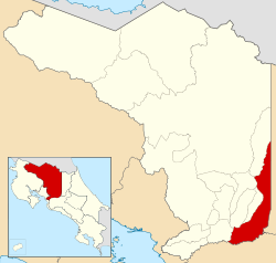
 Location of Alajuela Canton in Alajuela Province | ||
| Country | Costa Rica | |
| Province | Alajuela | |
| Area | ||
| • Total | 388.43 km2 (149.97 sq mi) | |
| Population (June 2013) | ||
| • Total | 285,259 | |
| • Density | 730/km2 (1,900/sq mi) | |
Alajuela is the name of the first canton in the province of Alajuela in Costa Rica. The canton covers an area of 388.43 square kilometres (149.97 sq mi),[1] and has a population of 285,259 (estimate as of 2013).[2] Its capital is the provincial capital city of Alajuela.
Northward from the city of Alajuela, the canton continues along the border with the province of Heredia to its east, encompassing a strip of the Cordillera Central (Central Mountain Range) between Poas Volcano and Barva Volcano. On the Caribbean side of the mountains, the canton takes in a portion of the Sarapiquí area. The Río Poás (Poas River) forms the major portion of the canton's western border, finally giving way to the Río Poasito as the territory ascends into the Cordillera Central.
Southwest of the city of Alajuela, the canton of Alajuela ends at the confluence of the Río Grande (Great River) and the Río Virilla (Virilla River).
Districts
The canton of Alajuela is subdivided into 14 districts (distritos):[3]
- Desamparados
- Turrúcares
- Tambor
- Garita
- Sarapiquí
History
Alajuela was first mentioned as a canton in a decree dated December 7, 1848. It is a major area for the production of coffee, strawberries and ornamental plants.
References
- ↑ Instituto Geográfico Nacional (IGN), 2001
- ↑ Estadísticas Vitales 2013 - INEC
- ↑ "División Territorial Administrativa de Costa Rica" (PDF) (in Spanish). Instituto de Fomento y Asesoria Municipal (IFAM). 5 May 2009.
Coordinates: 10°09′54″N 84°15′59″W / 10.16500°N 84.26639°W

