Araraquara
| Araraquara | |||
|---|---|---|---|
| Municipality | |||
|
| |||
| |||
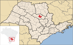
 Location in São Paulo state | |||
 Araraquara Location in Brazil | |||
| Coordinates: 21°47′41″S 48°10′34″W / 21.79472°S 48.17611°WCoordinates: 21°47′41″S 48°10′34″W / 21.79472°S 48.17611°W | |||
| Country |
| ||
| Region | Southeast Region | ||
| State | São Paulo | ||
| Government | |||
| • Mayor | Marcelo Fortes Barbieri | ||
| Area | |||
| • Total | 1,004 km2 (388 sq mi) | ||
| Elevation | 664 m (2,178 ft) | ||
| Population (2015) | |||
| • Total | 226,508 | ||
| • Density | 230/km2 (580/sq mi) | ||
| Time zone | BRT/BRST (UTC-3/-2) | ||
| Postal code | 14801 | ||
| Area code | +(55) 16 | ||
| Website | Official website | ||
Araraquara (Portuguese pronunciation: [ɐɾaɾɐˈkwaɾɐ] or [aˌɾaɾɐˈkwaɾɐ]) is a city in the state of São Paulo in Brazil. The population is 226,508 (2015 est.) in an area of 1004 km².[1] It is also known as "the abode of the sun," because of its impressive sunset and because of its hot atmosphere, especially in summer. The city was founded in 1817.
Ferroviária is the local football (soccer) team of the city. The club plays home matches at Estádio Fonte Luminosa, which has a maximum capacity of 27,000 people.
The city downtown is filled with bars, especially around colleges, as it has a high flux of students from nearby cities.
The city is served by Bartolomeu de Gusmão Airport.
The name of the city comes from the Tupi-Guarani language that mean "macaw's burrow".
References
External links
| Wikivoyage has a travel guide for Araraquara. |
- (Portuguese) Official website


