Baraundha
| Baraundha State Pathar Kachhar बरौंधा रियासत | |||||
| Princely State of British India | |||||
| |||||
|
Coat of arms | |||||
 | |||||
| History | |||||
| • | Established | 1549 | |||
| • | Independence of India | 1950 | |||
| Area | |||||
| • | 1892 | 565 km2 (218 sq mi) | |||
| Population | |||||
| • | 1892 | 17,283 | |||
| Density | 30.6 /km2 (79.2 /sq mi) | ||||
| Princely States of India A-J | |||||

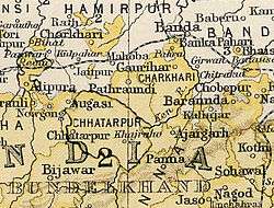
Baraundha (also known as Pathar Kachhar) was a princely state of colonial India, located in modern Satna district of Madhya Pradesh.[1] Although historically far larger, at the time of Indian independence in 1947, it was a petty Sanad state of about 565 km2.
History
The ruling family were members of the Raghuvansi line of Rajputs.[2][3]
Rulers
Thakurs
- 1790 - 4 Jan 1827 Mohan Singh (d. 1827)
- 1827 - 1867 Sarabjit Singh (d. 1867)
- 1867 - 1870 Dharampal Singh
- 1870 - 1874 Chhatarpal Singh (d. 1874)
- 1874 - 1885 Raghubar Dayal Singh (b. 1840 - d. 1885) (personal style Raja Bahadur from 1 Jan 1877)
- 18 Aug 1886 - 8 Jul 1908 Pratap Singh (b. 1847 - d. 108)
Rajas
- 1908 - 1933 Gaya Prasad Singh (b. 1865 - d. 1933) (Rajkumar Raghuvansh Pratap Singh, overlooked in the succession because of his part in the resistance movement —Jagirdar of Pindra)
- 1933 - 15 Aug 1947 Ram Pratap Singh
See also
References
Coordinates: 25°03′N 80°38′E / 25.050°N 80.633°E
This article is issued from Wikipedia - version of the 3/31/2016. The text is available under the Creative Commons Attribution/Share Alike but additional terms may apply for the media files.