Beit Sira
| Beit Sira | |
|---|---|
| Other transcription(s) | |
| • Arabic | بيت سيرا |
| • Also spelled | Bayt Sira (official) |
  Beit Sira Location of Beit Sira within the Palestinian territories | |
| Coordinates: 31°53′14.71″N 35°02′38.73″E / 31.8874194°N 35.0440917°ECoordinates: 31°53′14.71″N 35°02′38.73″E / 31.8874194°N 35.0440917°E | |
| Palestine grid | 154/143 |
| Governorate | Ramallah & al-Bireh |
| Government | |
| • Type | Village council |
| Area | |
| • Jurisdiction | 3,120 dunams (3.1 km2 or 1.2 sq mi) |
| Population (2006) | |
| • Jurisdiction | 2,749 |
| Name meaning | The house of the fold[1] |
Beit Sira (Arabic: بيت سيرا) is a Palestinian village in the central West Bank, located 22 kilometers west of Ramallah and is a part of the Ramallah and al-Bireh Governorate. The village is situated along the Green Line. During the 1948 Arab-Israeli War, around 4,000 dunams of its land became a part of the "No-Man's Land" strip between the north-central West Bank and Israel. Currently Beit Sira's jurisdiction is 3,120 dunams, of which 441 dunams are built-up areas and the remainder is open spaces for future construction or agricultural land.[2]
History
In 1596 Beit Sira was a part of the nahiya ("subdistrict") of Ramla, which was under the administration of the liwa ("district") of Gaza, in the Ottoman Empire. In the tax records that year it had a population of 17 household who were all Muslims. They paid a fixed tax-rate of 25 % on agricultural products, including wheat, barley, summer crops, vineyards, fruit trees, goats and beehives, in addition to occasional revenues; a total of 4,500 Akçe. All of the revenue went to a Waqf.[3]
In 1863 Victor Guérin noted Beit Sira as a considerable village on the summit of a rocky hill. A saint, revered under the name of Neby Sira, had a sanctuary there with his tomb.[4]
In 1883, the Palestine Exploration Fund's Survey of Western Palestine (SWP) described it: "A small village on a swell in the low hills. A main road passes through it. The water supply is artificial."[5]
Mandatory Palestine era
In the 1922 census of Palestine conducted by the British Mandate authorities, Beit Sira had a population of 381 Muslims,[6] increasing in the 1931 to 460 Muslims in 113 houses.[7]
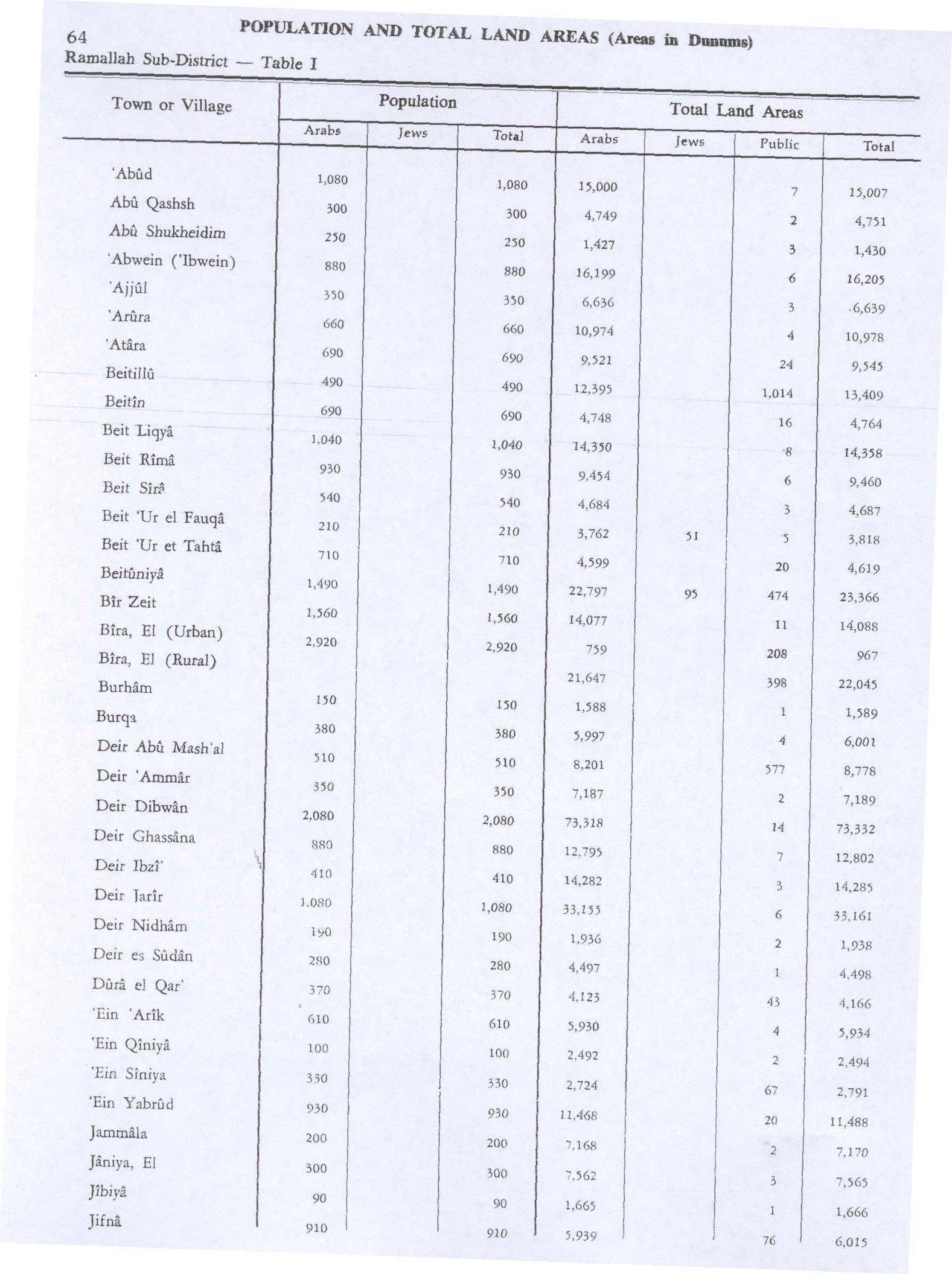
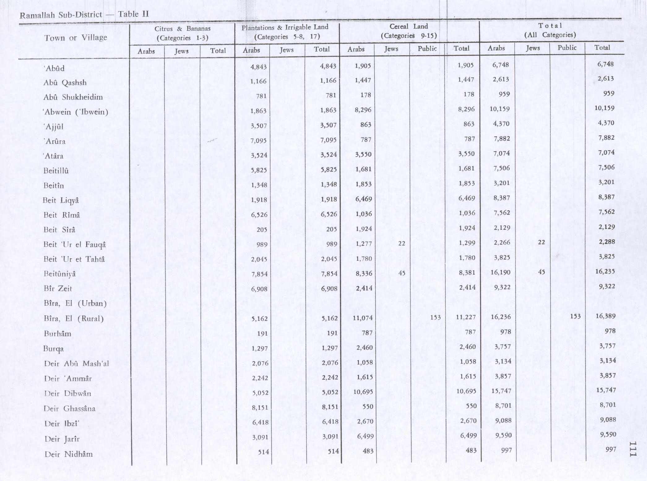
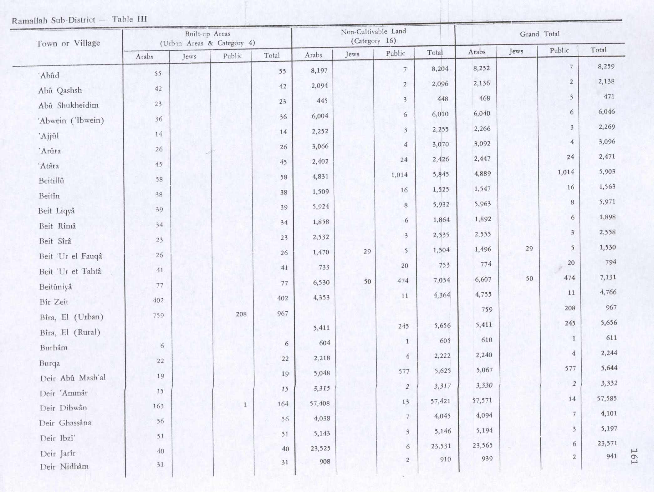
In 1945 the population was 540, all Muslims,[8] while the total land area was 4,687 dunams, according to an official land and population survey.[9] Of this, 205 dunams were plantations and irrigable land, 1,924 for cereals,[10] while 23 dunams were classified as built-up areas.[11]
1948-1967
In the wake of the 1948 Arab–Israeli War, and after the 1949 Armistice Agreements, Beit Sira came under Jordanian rule.
1967-present
After the Six-Day War in 1967, Beit Sira has been under Israeli occupation. According to the Palestinian Central Bureau of Statistics, Beit Sira had a population of 2,840 inhabitants in 2006.[12] In the 2007 PCBS census, there were 2,749 people living in the town.[13]
References
- ↑ Palmer, 1881, p. 287
- ↑ Beit Sira: A Palestinian Village on the verge of diminishing Archived November 19, 2016, at the Wayback Machine. Applied Research Institute - Jerusalem. 5 July 2004.
- ↑ Hütteroth and Abdulfattah, 1977, p. 156
- ↑ Guérin, 1868, pp. 337-338
- ↑ Conder and Kitchener, 1883, SWP III, p. 16
- ↑ Barron, 1923, Table VII, Sub-district of Ramallah, p. 16
- ↑ Mills, 1932, p. 47
- ↑ Department of Statistics, 1945, p. 26
- ↑ Government of Palestine, Department of Statistics. Village Statistics, April, 1945. Quoted in Hadawi, 1970, p. 64
- ↑ Government of Palestine, Department of Statistics. Village Statistics, April, 1945. Quoted in Hadawi, 1970, p. 111
- ↑ Government of Palestine, Department of Statistics. Village Statistics, April, 1945. Quoted in Hadawi, 1970, p. 161
- ↑ Projected Mid -Year Population for Ramallah & Al Bireh Governorate by Locality 2004- 2006 Palestinian Central Bureau of Statistics.
- ↑ 2007 PCBS Census. Palestinian Central Bureau of Statistics. p.114.

Bibliography
- Barron, J. B., ed. (1923). Palestine: Report and General Abstracts of the Census of 1922. Government of Palestine.
- Conder, Claude Reignier; Kitchener, H. H. (1883). The Survey of Western Palestine: Memoirs of the Topography, Orography, Hydrography, and Archaeology. 3. London: Committee of the Palestine Exploration Fund.
- Department of Statistics (1945). Village Statistics, April, 1945. Government of Palestine.
- Guérin, Victor (1868). Description Géographique Historique et Archéologique de la Palestine (in French). 1: Judee, pt. 1. Paris: L'Imprimerie Nationale.
- Hadawi, Sami (1970). Village Statistics of 1945: A Classification of Land and Area ownership in Palestine. Palestine Liberation Organization Research Center.
- Hütteroth, Wolf-Dieter; Abdulfattah, Kamal (1977). Historical Geography of Palestine, Transjordan and Southern Syria in the Late 16th Century. Erlanger Geographische Arbeiten, Sonderband 5. Erlangen, Germany: Vorstand der Fränkischen Geographischen Gesellschaft. ISBN 3-920405-41-2.
- Mills, E., ed. (1932). Census of Palestine 1931. Population of Villages, Towns and Administrative Areas. Jerusalem: Government of Palestine.
- Palmer, E. H. (1881). The Survey of Western Palestine: Arabic and English Name Lists Collected During the Survey by Lieutenants Conder and Kitchener, R. E. Transliterated and Explained by E.H. Palmer. Committee of the Palestine Exploration Fund.
External links
- Welcome To Bayt Sira
- Survey of Western Palestine, Map 17: IAA, Wikimedia commons
- Beit Sira Village (Fact Sheet), Applied Research Institute - Jerusalem (ARIJ)
- Beit Sira Village Profile, Applied Research Institute - Jerusalem (ARIJ)
- beit Sira, aerial photo, Applied Research Institute - Jerusalem (ARIJ)
- Locality Development Priorities and Needs in Beit Sira Village, Applied Research Institute - Jerusalem (ARIJ)
- The Israeli aggressive measures continue in Beit Sira village, POICA

| Cities |   | |
|---|---|---|
| Municipalities |
| |
| Village councils |
| |
| Refugee camps | ||