Bilokurakyne Raion
| Bilokurakynskyi Raion Білокуракинський район | |||
|---|---|---|---|
| Raion | |||
| |||
 | |||
| Coordinates: 49°37′2″N 38°42′23″E / 49.61722°N 38.70639°ECoordinates: 49°37′2″N 38°42′23″E / 49.61722°N 38.70639°E | |||
| Country |
| ||
| Region | Luhansk Oblast | ||
| Established | 1923 | ||
| Admin. center | Bilokurakyne | ||
| Subdivisions |
List
| ||
| Government | |||
| • Governor | Oleksandr Didenko | ||
| Area | |||
| • Total | 1,436 km2 (554 sq mi) | ||
| Population (2013) | |||
| • Total |
| ||
| Time zone | EET (UTC+2) | ||
| • Summer (DST) | EEST (UTC+3) | ||
| Postal index | 92200—92253 | ||
| Area code | +380 6462 | ||
| Website | http://bk.loga.gov.ua | ||
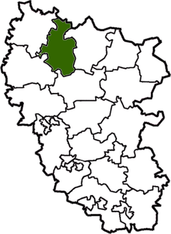
Bilokurakyne Raion (Ukrainian: Білокуракинський район) is a raion (district) in Luhansk Oblast in eastern Ukraine Oblast. The administrative center of the district is the urban-type settlement of Bilokurakyne. Population: 19,637 (2013 est.)[1].
After the proclamation of the separatist Luhansk People's Republic on 27 April 2014 the province of Luhansk became a battlefield of the War in Donbass.[2] Bilokurakyne Raion stayed under Ukrainian governmental control.[3] The separatist referendum on 11 May on independence was not held in the Raion.[4]
References
- ↑ "Чисельність наявного населення України (Actual population of Ukraine)" (in Ukrainian). State Statistics Service of Ukraine. Retrieved 21 January 2015.
- ↑ Ukraine crisis timeline, BBC News
- ↑ Latest from OSCE Special Monitoring Mission (SMM) to Ukraine based on information received as of 18:00 (Kyiv time), 4 November 2014, OSCE (5 November 2014)
- ↑ Any violations allowed in Luhansk Oblast referendum, Kyiv Post (11 May 2014)
This article is issued from Wikipedia - version of the 7/3/2016. The text is available under the Creative Commons Attribution/Share Alike but additional terms may apply for the media files.

