Canton of Wormhout
| Canton of Wormhout | |
|---|---|
| French canton | |
|
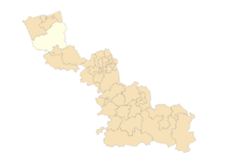
Map of the canton of Wormhout within the Nord department | |
| Country | France |
| Region | Hauts-de-France |
| Department | Nord |
| Arrondissement | Dunkirk |
| Seat | Wormhout |
| Communes | 45 |
| Area¹ | |
| • Total | 501.95 km2 (193.80 sq mi) |
| Population (2012) | |
| • Total | 52,712 |
| • Density | 110/km2 (270/sq mi) |
| ¹ French Land Register data, which exclude estuaries, and lakes, ponds, and glaciers larger than 1 km2. | |
Canton of Wormhout is an administrative division, located in Nord département and Hauts-de-France région in France. All communes of the canton of Wormhout are part of the arrondissement of Dunkirk.
Since the French canton reorganisation which came into effect in March 2015, the communes of the canton of Wormhout are:[1]
- Arnèke
- Bambecque
- Bavinchove
- Bissezeele
- Bollezeele
- Broxeele
- Buysscheure
- Crochte
- Eringhem
- Esquelbecq
- Hardifort
- Herzeele
- Holque
- Hondschoote
- Houtkerque
- Hoymille
- Killem
- Lederzeele
- Ledringhem
- Merckeghem
- Millam
- Nieurlet
- Noordpeene
- Ochtezeele
- Oost-Cappel
- Oudezeele
- Quaëdypre
- Rexpoëde
- Rubrouck
- Saint-Momelin
- Socx
- Steenvoorde
- Terdeghem
- Volckerinckhove
- Warhem
- Watten
- Wemaers-Cappel
- West-Cappel
- Winnezeele
- Wormhout
- Wulverdinghe
- Wylder
- Zegerscappel
- Zermezeele
- Zuytpeene
References
Coordinates: 50°51′20″N 2°22′20″E / 50.85556°N 2.37222°E
This article is issued from Wikipedia - version of the 11/18/2016. The text is available under the Creative Commons Attribution/Share Alike but additional terms may apply for the media files.

