Chinakakani
| Chinakakani చినకాకాని | |
|---|---|
| Village | |
|
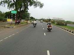
Chinakakani sign board on NH–16, Guntur district | |
 Chinakakani Location in Andhra Pradesh, India | |
| Coordinates: 16°24′16″N 80°33′28″E / 16.404570°N 80.557907°ECoordinates: 16°24′16″N 80°33′28″E / 16.404570°N 80.557907°E | |
| Country | India |
| State | Andhra Pradesh |
| District | Guntur |
| Mandal | Mangalagiri |
| Area[1] | |
| • Total | 10.83 km2 (4.18 sq mi) |
| Elevation[2] | 21 m (69 ft) |
| Population (2011)[3] | |
| • Total | 7,040 |
| • Density | 650/km2 (1,700/sq mi) |
| Languages | |
| • Official | Telugu |
| Time zone | IST (UTC+5:30) |
Chinakakani is a village in Guntur district of the Indian state of Andhra Pradesh. It is located in Mangalagiri mandal of Guntur revenue division.[1]
Demographics
As of 2011 census, Chinakakani had a population of 7,040. The total population constitute, 3,561 males and 3,479 females —a sex ratio of 977 females per 1000 males. 748 children are in the age group of 0–6 years, of which 389 are boys and 359 are girls —a ratio of 923 per 1000. The average literacy rate stands at 69.68% with 4,384 literates.[3]
Government and politics
Chinakakani gram panchayat is the local self-government of the village.[4]
Transport
The National Highway 16 passes through the village, which connects Chennai and Kolkata.[5] APS RTC operates bus services from Vijayawada, Guntur and Mangalagiri to this village.
See also
References
- 1 2 "District Census Handbook - Guntur" (PDF). Census of India. p. 14,270. Retrieved 18 January 2015.
- ↑ "Elevation for Chinakakani". Veloroutes. Retrieved 21 October 2014.
- 1 2 "Census 2011". The Registrar General & Census Commissioner, India. Retrieved 21 October 2014.
- ↑ "Angalakuduru Village Panchayat". National Panchayat Portal. Retrieved 6 May 2016.
- ↑ "Axe may fall on firm for delay in national highway expansion - Times of India". The Times of India. Retrieved 2016-06-05.

