Chiuiești
| Chiuiești | |
|---|---|
| Commune | |
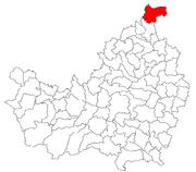
 Location in Cluj County | |
 Location on Romania map | |
| Coordinates: 47°17′40″N 23°52′30″E / 47.29444°N 23.87500°ECoordinates: 47°17′40″N 23°52′30″E / 47.29444°N 23.87500°E | |
| Country |
|
| County | Cluj County |
| Status | Commune |
| Settled | 1467[1] |
| Commune seat | Chiuieşti |
| Villages | Chiuiești, Dosu Bricii, Huta, Măgoaja, Strâmbu, Valea Cășeielului, Valea lui Opriș |
| Government | |
| • Mayor | Gavril Mihuț |
| Area | |
| • Total | 112.51 km2 (43.44 sq mi) |
| Population (2011)[2] | |
| • Total | 2,332 |
| • Density | 21/km2 (54/sq mi) |
| Time zone | EET (UTC+2) |
| • Summer (DST) | EEST (UTC+3) |
| Area code(s) | +40 x64[3] |
| Website | http://www.cjcluj.ro/chiuiesti/ |
Chiuiești (Hungarian: Pecsétszeg) is a commune in Cluj County, Romania. It is composed of seven villages: Chiuiești, Dosu Bricii (Bricshát), Huta (Huta), Măgoaja (Hollómező), Strâmbu (Horgospataka), Valea Cășeielului (Kesiel) and Valea lui Opriș (Oprisvölgy).
Demographics
At the 2011 census, Chiuiești had a population of 2332, of whom 98.8% were ethnic Romanians and 1.1% Roma.[2]
References
- ↑ Atlasul localităţilor județului Cluj, Editura Suncart, p. 125
- 1 2 (Romanian) Populația stabilă după etnie - județe, municipii, orașe, comune, National Institute of Statistics; accessed August 26, 2015
- ↑ x is a digit indicating the operator: 2 for the former national operator, Romtelecom, and 3 for the other ground telephone networks
This article is issued from Wikipedia - version of the 8/28/2015. The text is available under the Creative Commons Attribution/Share Alike but additional terms may apply for the media files.

