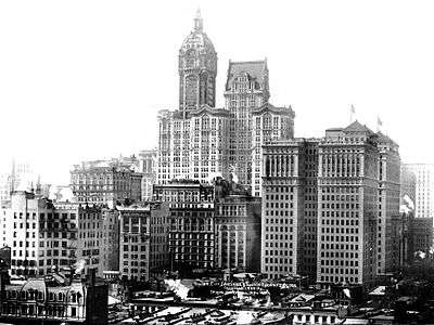
City Investing Building

The City Investing Building was an early New York City skyscraper, erected in 1908 as one of the largest buildings of its era. It was razed in 1968.[1]
The building stood at 56 Cortland Street, between Broadway and Church Street, and was constructed between 1906 and 1908. The architect was Francis Kimball, and construction was done by the Hedden Construction Company of New Jersey. With a single 33-story tower, a main body mass extended to 26 stories, and an asymmetrical F-shaped footprint because of a real estate holdout, the Gilsey Building.[2]
Along with the neighboring 1908 Singer Building (briefly the tallest building in the world) the 1908 Hudson Terminal (the largest office building of its time), the mammoth 1915 Equitable Building, and others, the City Investing Building stood as one of the most frequently photographed downtown skyscrapers, and a demonstration, for good or bad, of urban density. The Equitable Building threw the City Investing Building into permanent shadow up to the 24th floor,[3] a situation which led to New York City's 1916 Zoning Resolution requiring building setbacks.
From 1928 through 1932 it was known as the Benenson Building, then simply as its address, 165 Broadway.[4]
The building was razed in 1968, along with the nearby Singer Building, to make room for One Liberty Plaza. At the time of their destruction the Singer Building was the tallest building ever demolished; and the City Investing Building was the second. As of 2011, they are the third and eighth tallest to have been destroyed.
References
- ↑ New York Times: "Twins, Except Architecturally" By CHRISTOPHER GRAY August 29, 2013
- ↑ Landau, Sarah Bradford; Condit, Carl W. (1999), Rise of the New York Skyscraper: 1865-1913, Yale University Press, p. 323, ISBN 9780300077391
- ↑ "Shadows Cast by Skyscrapers", Building Management, November 1918, page 38
- ↑ The American skyscraper, 1850-1940: a celebration of height By Joseph J. Korom, page 273
Sources
External links
![]() Media related to City Investing Building at Wikimedia Commons
Media related to City Investing Building at Wikimedia Commons
Coordinates: 40°42′35.49″N 74°0′40.02″W / 40.7098583°N 74.0111167°W
