Coelbren, Powys


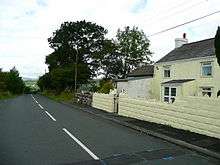
Coelbren is a small rural village just south of the Brecon Beacons National Park in Powys, Wales. It lies some six miles north-east of Ystradgynlais, close to Sgwd Henrhyd, a high waterfall on the Nant Llech. To the east of the village flows the Afon Pyrddin which plunges over two more spectacular falls.
History
The Roman road of Sarn Helen runs close to the village on its eastern side. Its remains and that of a Roman fort are now much degraded. The Brecon Forest Tramroad was constructed through the village in the 1820s. Of note to the east of Coelbren is the site of Banwen Ironworks, whose partial survival is owed to its early failure. It was constructed in the 1840s by speculators from London but may have produced only 80 tons of pig iron, the whole exercise being enveloped in a financial scandal.[1]
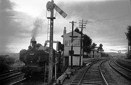
From the 1873, Coelbren was the location of a significant junction on the Neath and Brecon Railway whence a 7-mile branch diverged leading to the Swansea Vale Railway at Ynysygeinon. The contractor John Dickson had a terrace of houses constructed quite possibly for navvies working on the line and known originally as Dickson's Row though now known as Price's Row.[2] The lines closed in 1962 though the trackbed can still be seen almost encircling the eastern part of the village. The route to Swansea Vale has now been converted into a cycleway as Route 43 of the National Cycle Network linking the village with Ystradgynlais; it is planned that the trackbed northwards towards Brecon should also form part of Route 43. The A4109 Inter Valley Road between Glynneath and Abercraf passes to the immediate south of the village, its construction in the early 20th century rendering the village less isolated than it had been hitherto.
References
External links
Coordinates: 51°47′30″N 3°40′07″W / 51.79167°N 3.66861°W
| Wikimedia Commons has media related to Coelbren, Powys. |
