Cruyt Spur
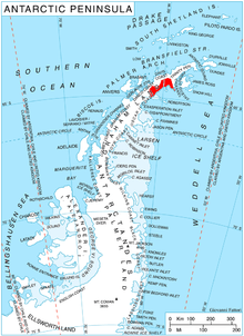
Cruyt Spur (64°37′S 60°42′W / 64.617°S 60.700°WCoordinates: 64°37′S 60°42′W / 64.617°S 60.700°W) is a rocky spur 4 nautical miles (7 km) northeast of Ruth Ridge and 3.85 miles (6.20 km) north-northeast of Papiya Nunatak, extending 2 nautical miles (4 km) southeast from the south wall of Detroit Plateau, on the Nordenskjöld Coast of Graham Land, Antarctica. It is surmounting Aleksiev Glacier to the northeast and Kladorub Glacier to the southwest. The spur was mapped from surveys by the Falkland Islands Dependencies Survey (1960–61), and named by the UK Antarctic Place-Names Committee for William Cruyt, a Belgian army engineer who designed the first "auto-polaire" in 1907.[1]
References
- ↑ "Cruyt Spur". Geographic Names Information System. United States Geological Survey. Retrieved 2011-12-08.
![]() This article incorporates public domain material from the United States Geological Survey document "Cruyt Spur" (content from the Geographic Names Information System).
This article incorporates public domain material from the United States Geological Survey document "Cruyt Spur" (content from the Geographic Names Information System).