D39 road (Croatia)
| |
|---|---|
| Route information | |
| Length: | 37.3 km (23.2 mi) |
| Major junctions | |
| From: |
|
|
| |
| To: |
|
| Location | |
| Counties: | Split-Dalmatia |
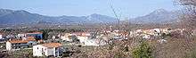
| Major cities: | Šestanovac |
| Highway system | |
| State roads in Croatia | |

D39 is a state road connecting the Aržano and nearby border crossing to Bosnia and Herzegovina D8 state road north of Brela.[maps 1]
The road also serves as a connecting road to the A1 motorway as it is connected to Šestanovac interchange via a short connector road.[1] The northern terminus of the road is located at Aržano border crossing, providing access to Livno in Bosnia and Herzegovina. The road is 37.3 km (23.2 mi) long.[2]
The road, as well as all other state roads in Croatia, is managed and maintained by Hrvatske ceste, a state-owned company.[3]
Traffic volume
Traffic is regularly counted and reported by Hrvatske ceste, operator of the road.[4] Substantial variations between annual (AADT) and summer (ASDT) traffic volumes are attributed to the fact that the road serves as a connection to the A1 motorway and the D8 state road carrying substantial tourist traffic.
| D39 traffic volume | ||||
| Road | Counting site | AADT | ASDT | Notes |
| |
5511 Cista Provo | 991 | 2,086 | Adjacent to the D60 junction. |
| |
5908 Cista Provo south | 1,339 | 2,760 | Adjacent to the Ž6171 junction. |
| |
5903 Gornja Brela | 2,907 | 6,372 | Adjacent to the Ž6166 junction. |
Road junctions and populated areas
| D39 junctions/populated areas | |
| Type | Slip roads/Notes |
| |
Aržano border crossing. The road extends into Bosnia and Herzegovina towards Livno. The northern terminus of the road. |
| |
Ž6154 to Gornja Tijarica and Donja Tijarica (D220). |
| |
Aržano Ž6155 to Studenci and Lovreć (D60). |
| |
Svib |
| |
Cista Provo |
| |
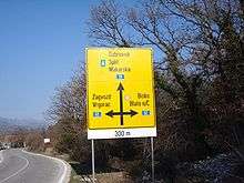
Ž6171 to Katuni and Kreševo. |
| |
Ž6172 to Žeževica. |
| |
Šestanovac Ž6260 to Blato na Cetini and Dugopolje. |
| |
|
| |
Zadvarje |
| |
Ž6166 to Slime and Kučiće. |
| |
Gornja Brela |
| |
The southern terminus of the road. |
Maps
- ↑ Overview map of the D39 (Map). OpenStreetMap. Retrieved August 19, 2014.
Sources
- ↑ "Regulation on motorway markings, chainage, interchange/exit/rest area numbers and names". Narodne novine (in Croatian). April 24, 2003.
- ↑ Ministry of Sea, Transport and Infrastructure (Croatia) (May 10, 2013). "Odluka o razvrstavanju javnih cesta" [Decision on categorization of public roads]. Narodne novine (in Croatian) (066/2013).
- ↑ "Public Roads Act". Narodne novine (in Croatian). December 14, 2004.
- ↑ "Traffic counting on the roadways of Croatia in 2013 - digest" (PDF). Hrvatske Ceste. May 2014. Retrieved 2014-08-19.
